To download the full report of the workshop, click here.
Satellite services that could support decision-making in cities exist, as well as funding mechanisms to develop new services better adapted to user needs.
“City administrations are at the forefront to solve emerging challenges.” Cristina Martinez, Smart Mobility and Living, European Commission, DG CONNECT
Satellites offer reliable data on cities’ assets, soil and air that can be compared over time and shared among different city departments. During the workshop, the speakers provided different examples of uses of satellite-based services in cities.
For the production and management of solar energy, EO data can help cities to exploit unused roofs or parking spaces to produce green energy. In Sun We Trust and NextSENSE are two online portals (respectively developed by MINES ParisTech and the National Observatory of Athens within the e-shape project), that provide data on solar radiation at the city level.
Earth observation also carries precious information to foresee soil subsidence and prioritise the maintenance of buildings, infrastructure and street pavements.
The Department of Engineering of the City of Amsterdam has been working with SkyGeo to use EO data to better monitor bridges in the historical city centre. More recently, the Segura River Basin Authority has worked with the Spanish Geological and Mining Institute (IGME) to use EO data to foresee soil subsidence due to groundwater extraction in the Segura River Basin (in Spain) and identify safe pumping sites.
Moreover, EO data can help cities to monitor parameters — such as the presence of pollutants in the air — that can heavily affect urban health. Within the workshop, the National Observatory of Athens presented an online platform (the SMURBS SDG indicator 11.6.2 Earth observation platform) that makes available data on fine particulate matter in cities based on satellite imagery.
Within the CURE project (Copernicus for Urban Resilience in Europe) satellite data originating from different Copernicus services is combined with demographic and economic data to help local authorities testing ‘what if’ scenarios, e.g. to estimate the health cost savings of low-carbon transport policies.
To favour the development of innovative technological solutions that can benefit cities, the European Commission makes available support and funding, and under such frameworks, cities, private companies and research institutes are invited to collaborate to develop services that could support decision-making in the long term.
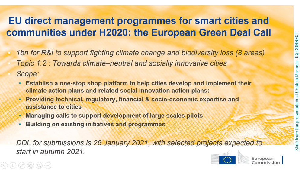
In the second semester of 2020 only, the Horizon 2020-funded European Green Deal Call makes available more than a billion euros to boost the green and digital transition, with specific calls for urban solutions.
Nevertheless, innovation produced within projects struggles to be integrated operationally into cities’ procedures.
“Usually those products are perceived as being too technical, especially for small and medium-sized cities that lack technical staff.” Pablo Ezquerro Martin, Spanish Geological and Mining Institute (IGME)
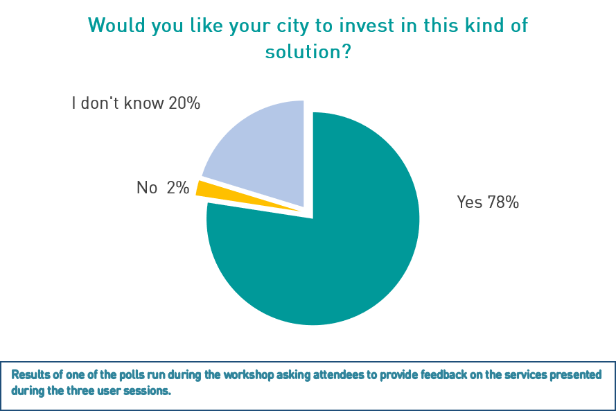
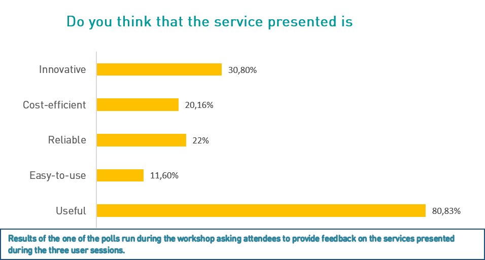
While most attendees to the Eurisy workshop considered that the services presented were worth investing in, some of the speakers also pointed out that these solutions are still perceived as being expensive and difficult to integrate into the decision-making processes of city departments.
This is particularly true when they lack in-house technical skills to process the data. In other cases, the uptake of satellite-based services is hindered by the cost of the high-resolution images needed to obtain relevant information on precise city areas.
There is still a lack of awareness among public administrations about the existence of services based on satellite applications, and in particular on Earth observation.
“In the scientific community, we are used to talk about our products in a scientific way, taking for granted that our audience is also an expert. In our experience, we have tried to explain our results to the stakeholders always relating them to their necessities and they usually thank us for this effort.” Pablo Ezquerro Martin, Spanish Geological and Mining Institute (IGME)
While big cities may have in-house staff with the technical skills to understand and use satellite-based services, most small and medium-sized cities do not get interested in these services until they are properly marketed to them.
Pressed by the need of prioritising expenditures to respond to changing priorities, local administrations are generally uncertain about the extent of time and resources needed to uptake services based on satellite data, and have often unrealistic or mismatched expectations towards them.
Indeed, while attendees of the workshop gave a very positive feedback about the usefulness of the satellite-based solutions presented to them, only a minority considered them as being “easy-to-use”.
The need to better communicate about the existence and the potential of such services among public administrations has been highlighted by Eurisy since the beginning of its User programme more than ten years ago and it is still extremely relevant today.
Marketing satellite-based services can be a challenge for both academics, researchers and private companies developing these solutions. To interest local managers towards innovative solutions, these need to become mainstream.
“People need to see the benefits for their everyday life through TV commercials and interviews, with no scientific and complex concepts. They just want simple solutions for effortless benefit and profit. The urban planners and decision makers necessarily follow the popular trends, so public opinion is the first to be convinced of the viability of satellite-based services. It’s not an easy task.” Panagiotis Kosmopoulos, National Observatory of Athens
Academics and researchers are not always able to explain the functioning and benefits of satellite-based services to their intended users.
Nevertheless, their proximity with public administrations makes them quite aware of their needs and often favours relationships of trust that can allow them to co-operate on research projects and to test innovative solutions.
If researchers struggle to communicate on satellite-based services to cities, also private companies face challenges to convince local administrations of the reliability and cost-efficiency of such solutions.
The main difficulty reported by private companies when trying to sell their services to local administrations is their resistance to trust products that are not yet of common use.
Culture and resistance to change are hence identified as important issues to be addressed to stimulate the uptake of innovation in cities.
Many cities would need support to procure satellite-based services
“When a city is eager to use a service, they need an expert to assist in drafting the technical specifications of their procurement tenders and to make sure that they get the best service for limited resources.” Carl Pucci, Urban Innovation Expert
Services based on Earth observation are still far from being mainstream, which makes it difficult for local administrations to consider them when writing their procurement tenders.
Moreover, even when city administrations are interested in satellite-based services, procuring them might not be obvious.
Cities also often lack in-house experience to write the technical specifications to procure them and to select the service that would better respond to their needs.
To favour the uptake of services based on Earth observation in cities there is need to expose the general public to convincing case studies.
“Beyond user requirements, cities are hampered by budget constraints and low innovation culture – however the effectiveness/ efficiency arguments supporting ICT investment are fully compelling and may be viewed as a solution to financial pressure. But for these arguments to win through, the services need to prove to be fit for purpose.” David Ludlow, CURE project “Copernicus for Urban Resilience in Europe”
If the attendees to the Eurisy workshop generally agree on the usefulness of the satellite-based services presented during the event, only a fraction of them was convinced of their reliability and cost-efficiency.
This pinpoints to the need for more case studies to demonstrate the viability of satellite-based services. These should highlight the cost-effectiveness of the services and their capacity to respond to cities’ concrete operational needs.
Additionally, they should indicate the amount of time and resources and the technical skills that local administrations are expected to deploy to acquire services targeted to their specific needs and, most importantly, to use them sustainably.
Finally, such case studies should be showcased in a non-technical jargon in events, newsletters and webpages targeting the general public.
The key to turn innovation into operation is to focus on needs
“I think that all panellists agreed on the importance of focusing our products on societal needs, and to me that is a step in the right direction.” Pablo Ezquerro Martin, Spanish Geological and Mining Institute (IGME)
To focus on needs means to involve city administrations actively in all phases of R&D projects, which requires a prior process of mutual education between city administrations and service providers (be them research institutes or private companies).
On the one hand, service providers need to learn about the priorities and needs of city departments, and about their current structure, capabilities, and operational functioning.
On the other hand, public administrations need to understand what parameters satellites can monitor, at what resolution and how often, and need to be aware of the time and resources they are expected to invest to obtain a viable service.
The speakers contributing to our workshop are well aware that the transfer of satellite-based services to cities can only happen if these are clearly adapted to the operational needs and capabilities of local administrations.
If all stakeholders focus their communications on such aspects, they can find the common language needed to co-design scalable satellite-based solutions that can be broadly used to improve life in cities.
Eurisy will continue working in this direction and will keep creating spaces for dialogue among all the stakeholders interested in transferring the benefits of space to civil society.