Building Connections for a Safer Tomorrow: Disaster Risk Management Insights from Luxembourg
On 30 October 2025, some 70 representatives from public authorities, research institutions, civil society, and the private sector gathered in Luxembourg to discuss challenges in disaster risk management (DRM) and explore the potential of satellite technologies. The event, co-organised with the Luxembourg Space Agency, was part of a series of national workshops initiated by the European Union Agency for the Space Programme (EUSPA) and supported by Eurisy to raise awareness on the many possibilities offered by the EU space programmes to support disaster risk management.
Luxembourg faces a variety of natural hazards, including floods, storms, and wildfires. Changing weather patterns driven by climate change, combined with the country’s river basin geography, have increased both the frequency and severity of flooding events. In response, Luxembourg has reinforced its disaster management framework — an effort supported by its robust space industry, which plays an important role in advancing satellite-based monitoring and risk assessment. A key component of this strategy is the use of the Copernicus Emergency Management Service (CEMS), which Luxembourg has activated five times between 2012 and 2025: for landslides, post-flood analysis, a pre-risk economic assessment, and two training exercises. Notably, four of these activations took place outside of actual emergencies, reflecting Luxembourg’s proactive approach to disaster risk management.
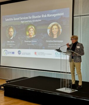
Dominique Tilmans, Eurisy president, giving her introduction speech
The event began with a series of welcoming speeches. Marc Serres, CEO of the Luxembourg Space Agency, emphasised Luxembourg’s leadership in using space-based solutions to enhance all phases of the disaster risk management cycle. He noted that since 2012, the country’s space sector has grown from 16 to 80 companies, with a significant part of that engaged in DRM supporting initiatives such as emergency.lu, which provides global connectivity services to humanitarian organisations, and supported by a national data center enabling easy access to Copernicus data. Eurisy president Dominique Tilmans, followed by explained the purpose of the day with the Eurisy–EUSPA series of workshops intended to bridge the gap between space innovation and real-world resilience by connecting decision-makers, scientists, and first responders. She highlighted Luxembourg’s national vision for space – where the sector represents 5% of GDP – and its robust DRM framework established in 2016 and noted how Luxembourg’s response to the 2021 floods (with 125 million€ in damages) demonstrated effective use of Copernicus Emergency Management Service (EMS) data for recovery planning.
The critical role of the EU space technology – Galileo, Copernicus and future GOVSATCOM and IRIS2 – in DRM was emphasised by Christina Giannopapa, Head of the Office of the Executive Director of EUSPA. She underlined the strength and potential of the European Union Space Programme in relation to DRM, noting Galileo’s status as the world’s most precise navigation system and Copernicus in providing the world’s best Earth observation data. She further highlighted Luxembourg’s considerable strengths in space, in particular its key role in global secure satellite communications. Finally Ms Giannopapa highlighted the importance of DRM to the focus EUSPA gives to raising market uptake of satellite services across 15 target sectors, of which DRM is one.
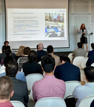
Following the welcoming speeches, as session on EU Components explored the role of EU space assets — Copernicus, Galileo, and the forthcoming GOVSATCOM and IRIS² — in supporting disaster risk management. Representatives from EUSPA underscored the importance of open satellite data, emergency mapping, and secure communications in strengthening Europe’s capacity to respond to crises. They highlighted that the Copernicus Emergency Management Service (CEMS) is used not only during emergencies but increasingly across all phases of DRM, including preparedness and recovery for risk assessments or post-event analysis. In addition, other Copernicus services also contribute to DRM, such as the Land Monitoring Service, gathering essential information for drought monitoring and landslide risk evaluation and the Climate Change Service, providing forward-looking modelling to anticipate future hazards. A presentation of Galileo explained the upcoming Emergency Warning Satellite Service, its benefits – reach, reliability, complementarity and scalability – and timeline, as well as highlighting the importance of the newly initiated Galileo authentication service in providing assured secure position navigation and timing signals. The session also emphasised the key role telecommunications play in ensuring secure, reliable and cost-effective communication during disasters, describing the aims of the current GOVSATCOM and future IRIS2 programmes.
Lastly, the availability of several key EU funding streams, notably through relevant Horizon Europe calls and the CASSINI programme (hackathons, entrepenneurship days, matchmaking events and the growth facility etc), were presented as key enablers of innovation and market development within the European DRM market and space ecosystem more generally.
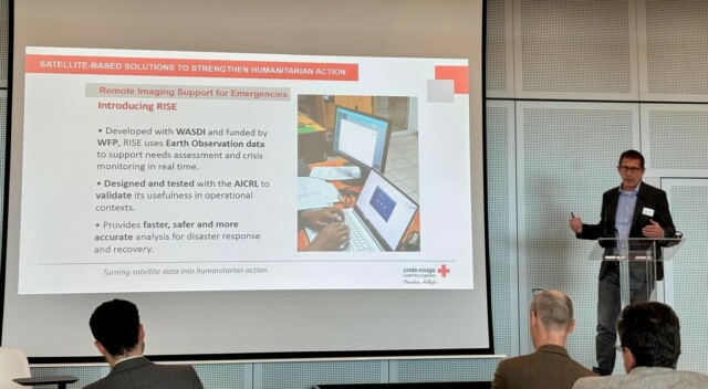
Daniel Ledesma, Head of the Innovation and Reference Unit at Luxembourg Red Cross presenting during the 1st afternoon session.
The first afternoon session on current challenges and opportunities related to the uptake of satellite data focused on how space technologies support humanitarian and emergency operations primarily from the user’s perspective. Speakers highlighted in particular how secure, reliable space-based communication networks and rapid access to Earth observation (EO) data are vital to saving lives in crises through ensuring that emergency workers can coordinate effectively amongst themselves, better understand the risks they are managing while also reducing their own exposure to those risks. At the same time they also acknowledged challenges in operating such services — including regulatory barriers, host government restrictions on satellite communications in humanitarian contexts, signal interference, jamming and spoofing, and cyber risks. A growing difficulty of operating in conflict zones was noted, where neutrality and independence can be compromised if technology providers are perceived to take sides and satellite services can be turned from civil to military use. Despite these political and ethical complexities, new satellite technologies offer powerful opportunities: global coverage, low-latency connections, and easier deployment, though affordability and regulatory acceptance remain uneven.
Concrete national examples showcased these dynamics in practice. Gilles Hoffmann explained how Luxembourg’s lu.emergency service provides rapid secure connectivity for humanitarian workers in the field while Steve Hoscheid described how its Renita network enables rapid deployment of mobile telecommunications cells using space-based relay to areas without adequate terrestrial mobile phone coverage. This ensures secure, mission-critical communication for public safety services such as police and firefighters. The Renita network also guarantees continuous coverage during floods – and is evolving towards a 5G-based, satellite-integrated system linked to IRIS² under the EU Critical Connectivity System (EUCCS). Another example presented by both Daniel Ledesma and Paolo Campanella highlighted how the Luxembourg Red Cross supported by start-up WASDI is using EO and rapid mapping technologies to transform humanitarian response. Recent tests have showed that using satellite-based tools to better assess natural risks to humanitarian camps can reduce response time by up to 80% with similar cost savings, offering near real-time situational awareness in areas otherwise difficult to access without considerable risk to workers. These technologies complement, rather than replace, the expertise of responders on the ground, helping them to plan recovery and reconstruction more effectively, with key enablers being the development of consistent language understood by both users and service providers and the creation of intuitive user interfaces. The panel as a whole reflected Luxembourg’s and Europe’s shared commitment to resilient, secure, and inclusive technological solutions that put people at the centre of crisis response.
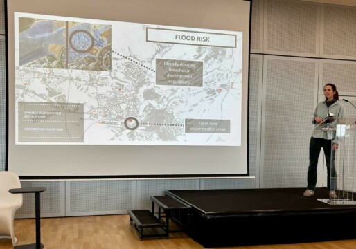
Charlotte Wirion, Co-founder and CTO of WEO presenting during the 2nd afternoon session.
The second afternoon session focused on Luxembourg’s space assets supporting DRM. Presentations highlighted how satellite data, AI and automation tools are transforming disaster risk management.
Guy Schumann of RSS Hydro highlighted the work of his company in flood mapping with particular reference to supporting humanitarian work where he noted demand for effective satellite image based analysis was huge but often poorly met. He pointed to the opportunity to better assess flooding impacts from a wider range of sensors including notably infra-red and through the future potential for multi-mission analysis, combining the data gathered by different types of EO satellites, to deliver even more effective information to planners and responders.
Fabio Romano of SES gave an overview of that company’s key roles in resilient European space services such as the EGNOS system, while highlighting the world-leading capabilities it possesses in the rapid establishment of temporary satellite communications relay stations. He underlined the importance of these in situations such as hurricanes, where mobile phone towers and undersea cables are destroyed or damaged, and SES’s ability to deliver extremely high bandwidths on demand in disaster zones drawing on its extensive range of space-based communications satellites operating in GEO, MEO and LEO.
Charlotte Wirion from start-up WEO highlighted her company’s focuses on the use of EO data for disaster planning, mitigation and preparedness as well as long-term monitoring for recovery. She described how using data from Copernicus and Landsat, WEO is addressing use cases such as flooding, the risk of wildfire propagation to critical assets and citizens, or the management of heat island risk to vulnerable local people and workers. WEO is particularly focused on improving resolution and hazard detection at the local level through combining satellite with ground based data and feedback from emergency services (eg noting the propensity for certain roads to flood) while also identifying solutions such as promoting green roofs or supporting citizens in clearing vegetation around homes with interventions as simple as chain saw training.
Gerald Schlueter of Govsat outlined the development of this public private partnership with a mission to provide secure resilient satellite services to European government users. He noted the advantages of having access to protected communications bands such as X and military Ka in reducing signal interference and highlighted Govsat’s relevance to a range of use cases through the DRM cycle notably the provision of assured, guaranteed communications in the case of recent flooding in Germany.
Finally, Marco Chini from the Luxembourg Institute for Science and Technology gave an impressive overview of a range of new techniques being developed within the Luxembourg research community to improve assessment and prediction of natural disasters in particular flooding using space based earth observation.
If you were unable to join us, you can find the presentations here.
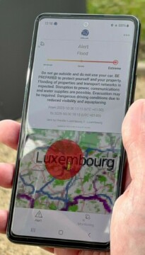
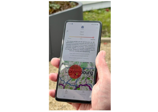
In the afternoon, participants also observed a demonstration of the upcoming Galileo Emergency Warning Satellite Service (EWSS). Currently in testing, the upcoming EWSS will send critical alerts and safety instructions directly to standard mobile phones in the device’s language, even in areas without terrestrial coverage. Complementary to other existing services, this innovation will deliver timely warnings to at-risk populations, broaden the reach of critical information and improve coordination during emergencies, representing a significant advance in Europe’s disaster communication capabilities.
Wrapping up the event, speakers in the final session emphasised how space-enabled services delivered by Luxembourg are delivering tangible operational benefits, from faster and more effective disaster response to safer field operations. The day provided valuable insights into the Luxembourg space sector while demonstrating how effective collaboration between government, industry, academia, and users strengthens the ecosystem and drives innovation. Transforming satellite data into actionable intelligence, integrating user feedback, and bridging space and non-space expertise were emphasised as critical for impact. The discussions underlined both the measurable successes of current solutions and the ongoing need to connect space and non-space communities, explore new opportunities, and continue building resilience and innovation in disaster management.
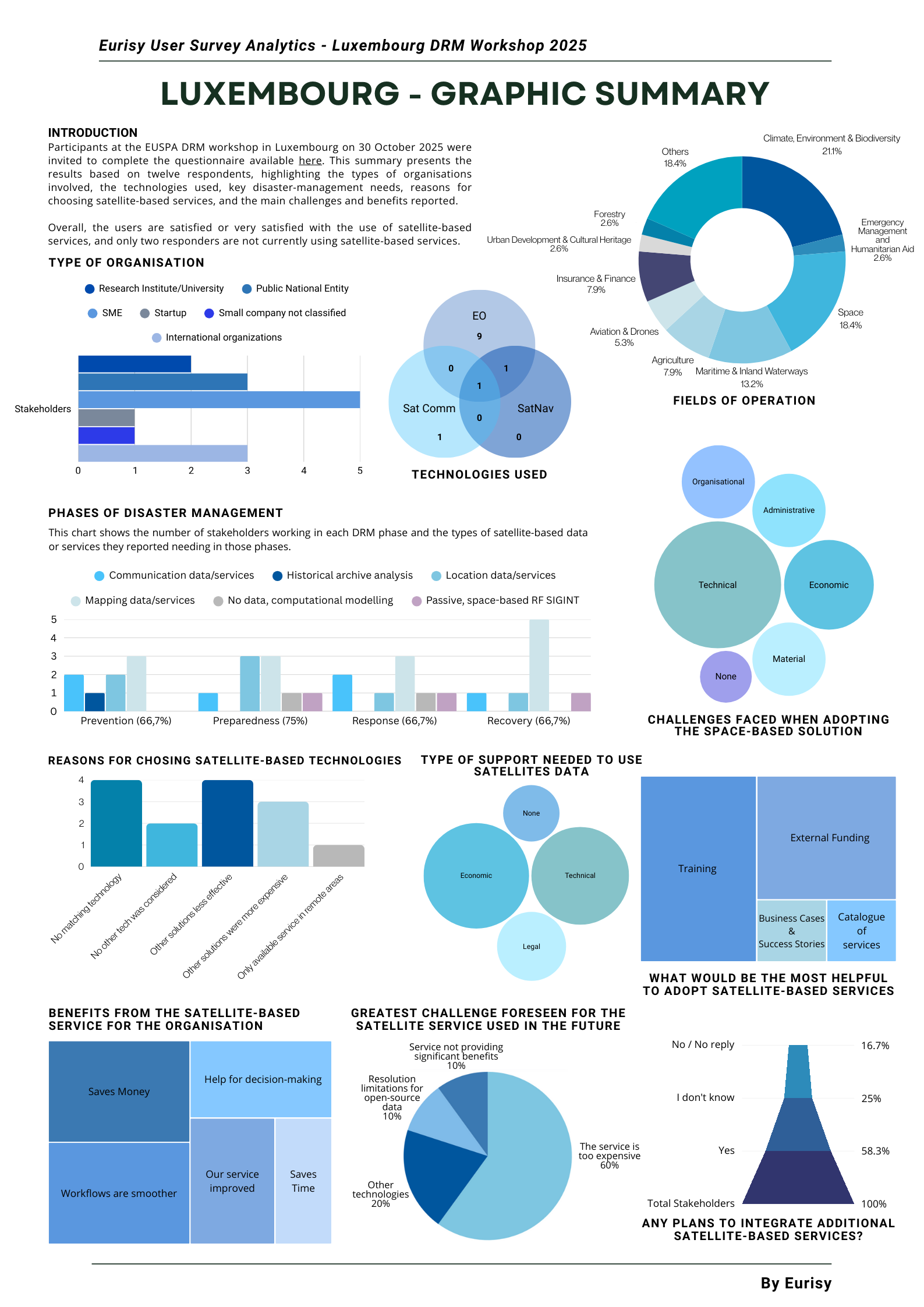
During the workshop, participants were also invited to complete a questionnaire available here on their uses of satellite-based services. You can find the results below: