Crisis by the Clock: Disaster Risk Management Insights from Czech Republic
On 9 December 2025, stakeholders from across the Czech disaster-management community – including national authorities, researchers, emergency services, civil-society organisations, and industry – met in Prague to discuss current Disaster Risk Management (DRM) challenges and the added value of satellite-based solutions. The workshop, held in cooperation with the Czech Ministry of Transport, formed part of a series of national workshops initiated by the European Union Agency for the Space Programme (EUSPA) and supported by Eurisy. Its purpose was to highlight how EU space services can be used throughout the disaster-management cycle, make these tools easier for practitioners to access, and collect insights on user needs.
The Czech Republic faces a range of natural hazards, from major floods and severe storms to prolonged droughts. Recent events such as the 2024 floods and the 2021 South Moravia tornado illustrate how climate change is amplifying the scale and frequency of extreme weather across the country. Strengthening disaster risk management has become essential, with space-based services supporting national efforts in monitoring, early warning, rapid response and recovery.
During the welcome remarks, representatives from the Czech Ministry of Transport, EUSPA and Eurisy highlighted the strong link between Europe’s space capabilities and disaster risk management. Speaking on behalf of the Czech Ministry of Transport, Lucie Kopecká, Space Policy Adviser, underlined the Czech Republic’s rapidly growing space sector and its relevance for crisis management, noting the country’s pride in hosting EUSPA’s headquarters in Prague. She stressed that organisations in the Czech Republic enjoy the benefits of the EU Space Programme components, such as Copernicus, Galileo and soon GOVSATCOM. She welcomed the high number of participants, seeing it as a clear indication of emergency responders’ strong interest in satellite-based services and their even greater potential for the future.
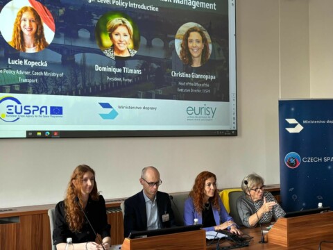 Christina Giannopapa, Head of the Office of the Executive Director at EUSPA, emphasised that EU space technologies are now indispensable for disaster risk management, combining the strengths of Copernicus, Galileo and GOVSATCOM to provide reliable data, precise positioning and resilient connectivity when it is needed most. She highlighted the Czech Republic as an ideal host for the workshop, given its dynamic space ecosystem and strategic commitment to resilience. Eurisy president, Dominique Tilmans, focused on the importance of ensuring that space-based services are accessible and truly operational for users on the ground. She stressed that collaboration between national actors and European institutions is essential to translate technological capability into real societal value, citing examples such as Copernicus Emergency Management Service activations during recent floods in Czech Republic, and noting the important role satellites play in ensuring resilience where they are sometimes are the only service providing reliable situational data.
The following session on EU Space Components examined how Europe’s space assets support disaster risk management and emergency response. Vasilis Kalogirou, Space Downstream Research & Innovation Officer at EUSPA outlined how Copernicus supports DRM through near-real-time mapping from the Emergency Management Service (CEMS), along with land use and ground-motion monitoring. He further stressed CEMS’ strong focus on users, explaining they carry tailored demonstrations, for instance with the Czech Red Cross. He pointed however out that while Copernicus services offer crucial insights for floods, wildfires and other hazards, awareness and uptake remain key challenges. Flavio Sbardellati, Governmental and Downstream Research & Innovation Manager at EUSPA then
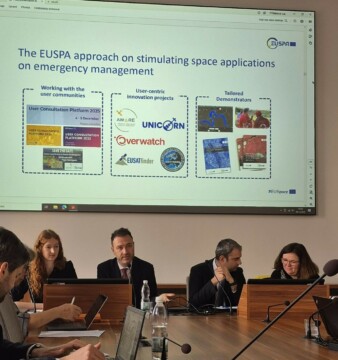
explained the role of secure satellite communications for DRM. He noted that GOVSATCOM and future IRIS2 are designed to ensure reliable connectivity for civil protection and users when terrestrial networks fail. He also described Europe’s Space Surveillance and Tracking system (EU SST), which offers protection through collision avoidance, fragmentation and re-entry analysis, essential as space becomes increasingly crowded. The Galileo programme was then presented by Vincent Chatelée, Galileo EWSS and SAR Service Manager at EUSPA. He focused on Galileo’s evolution beyond positioning, presenting the upcoming Open Service Navigation Message Authentication (OSNMA) aiming to counter spoofing and strengthen resilience, a first in the world. He also described the forthcoming Emergency Warning Satellite Service (EWSS), aiming to broadcast alerts directly to the public via satellite when terrestrial networks fail, its ongoing pilots and the path toward its initial operational service in 2026. Finally, the session presented CASSINI, the EU’s entrepreneurship and investment initiative, and relevant Horizon Europe opportunities. It was outlined how these programmes help startups and SMEs accelerate growth, commercialise innovative space-based solutions, and develop applications that strengthen Europe’s resilience, from climate and environmental monitoring to emergency response.
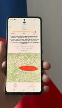
EWSS live demonstration
After the EU Space Component panel, the participant witnessed a live demonstration of the upcoming Galileo Emergency Warning Satellite Service (EWSS), a new capability designed to deliver fast, reliable alerts to populations at risk during disasters. Building on the precision and resilience of the Galileo navigation system, EWSS enables authorities to broadcast location-based warning messages directly to compatible devices, even when conventional communication networks are disrupted. Complementing existing services, this innovation will provide timely alerts to at-risk populations, expand the dissemination of vital information, and enhance coordination during emergencies, marking an important step forward in Europe’s disaster communication capabilities.
The first afternoon session showcased how space-based data is increasingly being translated into practical tools for DRM. Opening the panel, Boris Procházka of GINA Software, emphasised that the real challenge is not the quantity of satellite data available, but in ensuring it is usable by first responders. By looking at the entire chain of command – from the onset of a hazard through to rescue operations – his team focuses on integrating Earth Observation data directly into the tools and devices already used by field commanders and emergency crews. Thus, satellite data can be quickly integrated to decision-making and support everything from initial situational awareness to logistics, coordination and recovery. He concluded by stating that the technology is already there, the challenge now is understanding user needs to maximise satellite data impact during a crisis.
Jan Jelenek of the Czech Geological Survey followed with practical illustrations of how combining Copernicus satellite data with drone observations enables effective rapid assessment in DRM such as effective monitoring of landslides, surface deformation, and forest fires. As part of the Survey’s mandate to produce national risk analyses, he explained that leveraging space-based data allows authorities to obtain fast, reliable situational insight at moments when ground access is limited or too slow. He went on to describe ongoing research aimed at improving hazard prediction and reinforcing the scientific basis for crisis preparedness. Together, these activities illustrate how Czech scientific expertise is turning European space data into actionable, decision-ready information that directly supports disaster risk management both domestically and abroad.
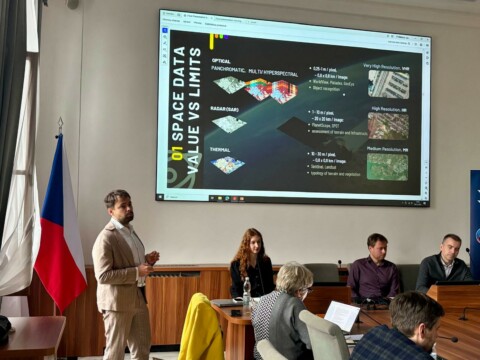
Building on the operational theme, Simon Seidl of World from Space (on the photo) focused on how different types of satellite imagery – optical, multispectral, radar and high-resolution – are selected and combined to support DRM efforts, depending on the nature of the crisis. Drawing on case studies such as the recent Turkey earthquake, Beirut port explosion and Czech tornadoes and floods, he detailed how satellite data support impact assessment, risk prioritisation, transport accessibility analysis and off-road navigation for emergency teams. He also underlined the importance of automated processing, AI-assisted analysis and co-development with responders to deliver clear, actionable intelligence within the tight timeframes of an emergency.
Closing the session, František Zadražil of the Czech Centre for Science and Society presented the role of artificial intelligence in enhancing environmental and disaster-related monitoring. Using examples from agriculture and forestry, he demonstrated how AI can compensate for cloud-obstructed or infrequent satellite imagery, generating consistent, decision-relevant insights for users. He also outlined future research on super-resolving land-surface temperature data, with applications for drought monitoring and fire risk assessment.
Taken together, these presentations illustrated how European space capabilities – when coupled with operational integration, user-driven design, scientific expertise and emerging AI techniques – are improving the speed, accuracy and usability of satellite data delivered to those responsible for managing crises on the ground.
The second afternoon panel shifted the focus from service providers to end users, highlighting the challenges and opportunities of integrating satellite applications into day-to-day operations across policing, communication and agricultural management. Opening the session, Tomas Dusa of GNSS Centre of Excellence assessed the national needs for GOVSATCOM and the forthcoming IRIS² secure communication services. He explained that from an operational standpoint, many institutions see secure satellite services primarily as a back-up for crisis situations but need to be confident of availability of service provision in those situations. At a technical level potential users emphasised the need for low latency, assured bandwidth and to be assured of the availability of compatible hardware. He emphasised the need for clear guidance, practical demonstrations and hands-on training to help authorities understand how secure European satellite communication can strengthen crisis-response readiness.
Vratislav Hruska of the Czech Police then underscored the critical role that space-enabled, secure communications play in day-to-day policing and emergency response. He stressed that when terrestrial networks do not exist, fail or become overloaded, satellite connectivity ensures that essential voice and data services remain available for officers in the field. Beyond communications, he noted that space-based capabilities significantly enhance situational awareness and operational coordination: real-time positioning of patrol units, search teams and specialised assets enables commanders to allocate resources more efficiently, maintain oversight across wide or hard-to-access areas, and monitor sensitive transports with greater confidence.
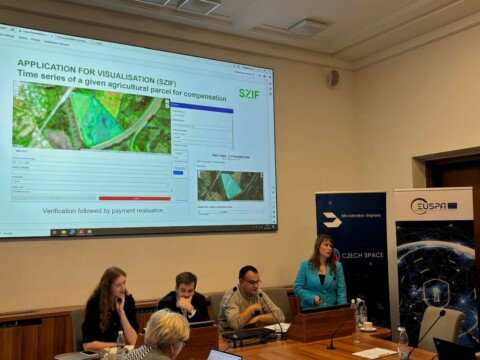
Closing the panel, Lucie Šavelková of the State Agricultural Intervention Fund presented how Earth-observation data supported emergency compensatory measures during the 2024 floods. Although Sentinel-based monitoring is already embedded in routine agricultural control systems, the floods exposed shortcomings in existing hazard maps, which did not reflect the actual direction and extent of water flow. With limited in-situ measurements and large agricultural areas affected, the Agency swiftly developed an in-house verification process drawing on Copernicus imagery, biomass indices and complementary VHR data. By comparing pre- and post-event conditions from space data and integrating aerial photographs, hydrological data and farmer declarations, analysts were able to identify genuinely damaged parcels, validate compensation claims and provide a transparent basis for emergency interventions.
Together, the user perspectives reinforced that space-based services are becoming indispensable components for DRM. Their effectiveness depends not only on technological capability, but on usability, training, integration with existing workflows and clear institutional support. By sharing concrete challenges and best practices, the panel highlighted how strengthening user readiness is essential to support crises management.
If you were unable to join us, you can find the different presentations here.
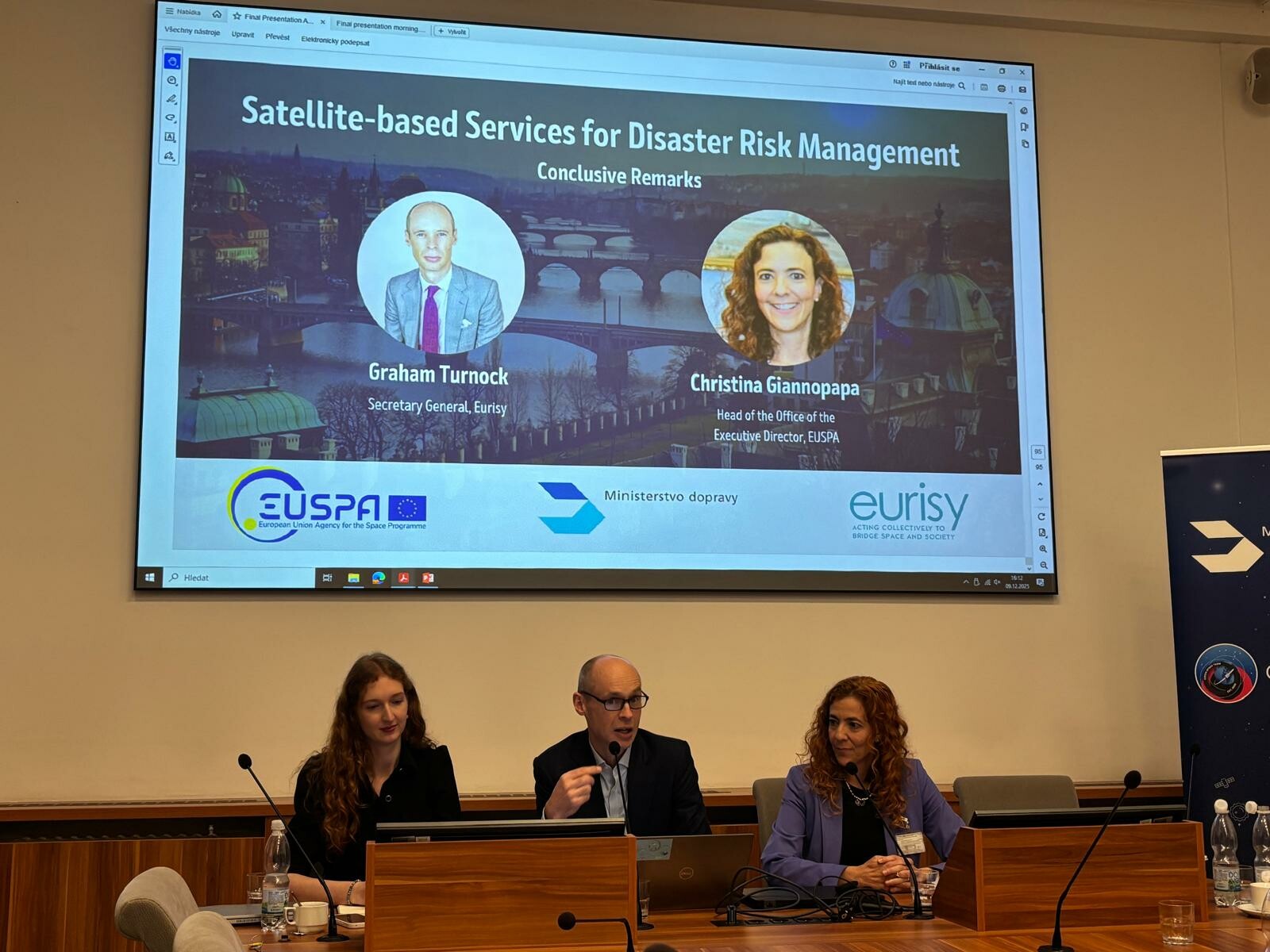
Wrapping up the event, Christina Giannopappa of EUSPA and Graham Turnock of Eurisy emphasised the core message of the day: space-based capabilities are becoming essential for modern crisis management, yet their impact ultimately depends on user-friendly design and practical usability. Across the sessions, speakers demonstrated how satellites, combined with terrestrial data, AI, drones and tailored applications, are already enabling real-time decision-making in sectors such as forestry, agriculture, policing and disaster response. They stressed the need to translate complex space services into simple, operationally usable tools that integrate smoothly with existing structures, requiring not just technical excellence but also advocacy within organisations and among decision-makers. Looking ahead, there was optimism about advances in AI, higher-resolution sensors, and future national and European constellations, which promise faster revisit times and even more actionable insights. The event also reaffirmed the strong partnership between national authorities, user communities and European space programmes.
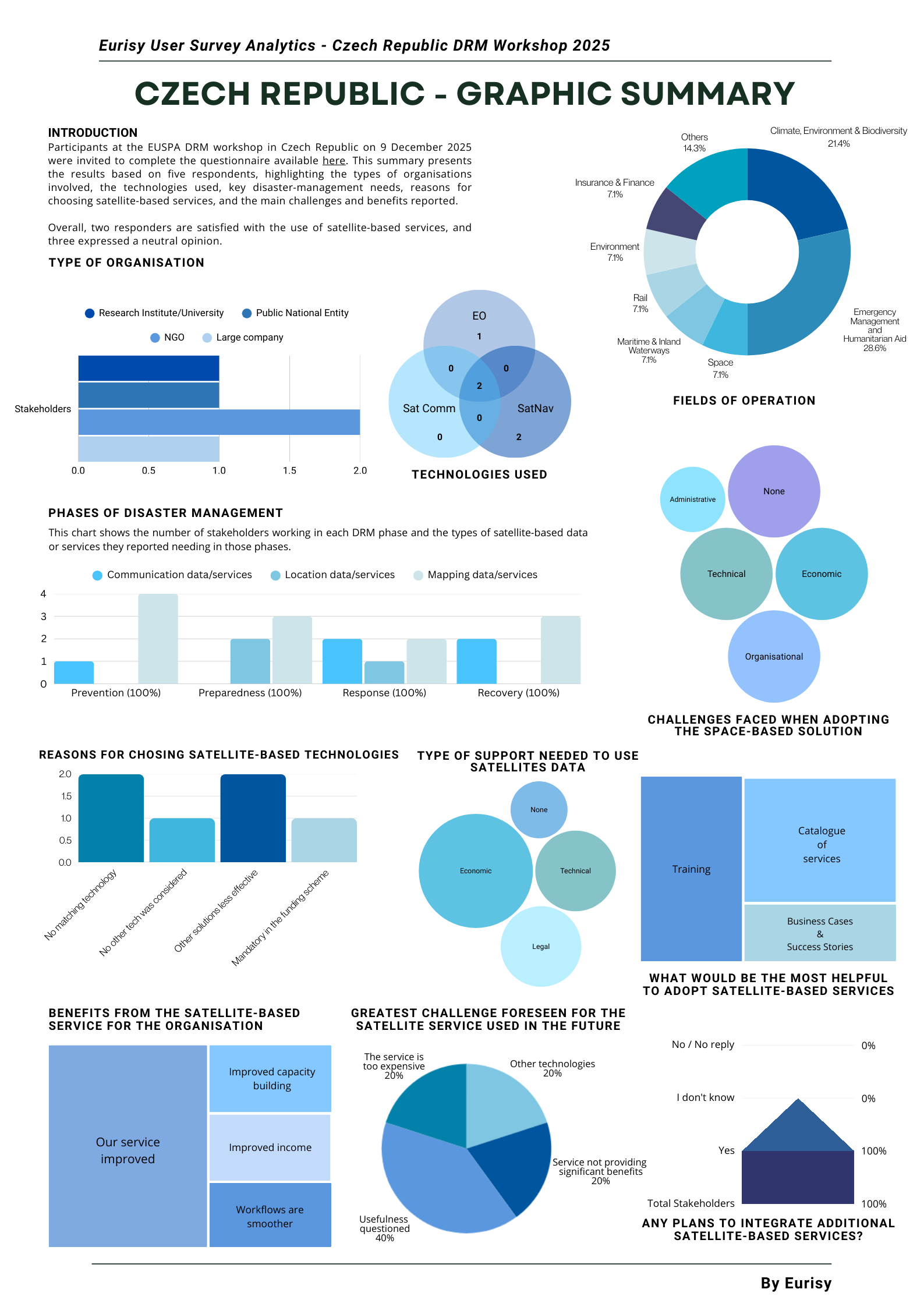
During the workshop, participants were also invited to complete a questionnaire available here on their uses of satellite-based services. You can find the results below: