Protecting Bonaire’s Waters with Satellite-Based Oil Spill Monitoring
Port of Bonaire
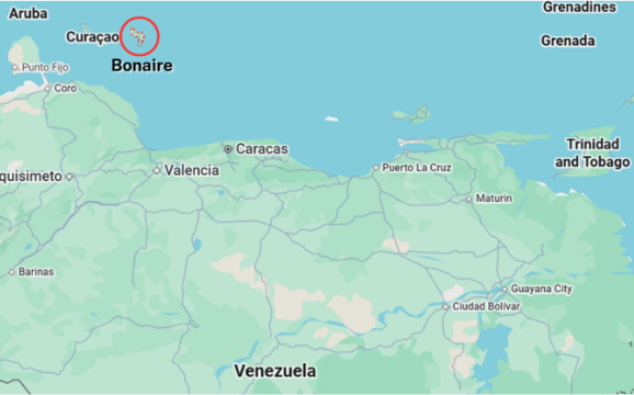
Located in the southern Caribbean Sea, just north of Venezuela, Bonaire is a small island municipality of the Netherlands, known for its exceptional marine biodiversity. Its waters host protected coral reefs, mangroves, and coastal ecosystems that are highly sensitive to pollution.
The Port of Bonaire is a key gateway for maritime traffic in the region, handling cargo, fuel shipments, and cruise vessels. Beyond port operations, the Harbour Master and his team are responsible for overseeing the island’s entire territorial waters. This includes managing ship movements, ensuring maritime safety, and mitigating and coordinating responses to incidents at sea. A major part of its work focuses on environmental protection. Oil spills, whether local or originating from neighboring countries, represent the most significant threat.
The challenge
Due to its geographic position and prevailing currents, Bonaire is particularly exposed to pollution drifting from regional shipping routes and industrial areas. Through regional currents, incidents occurring hundreds of kilometres away, particularly near Trinidad and Tobago or Venezuela, can directly impact its shores.
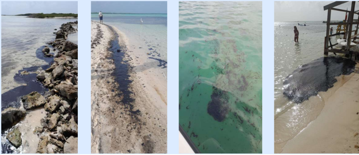
This vulnerability became evident in 2017, when oil reached Bonaire without prior warning. At the time, authorities lacked the tools to trace its origin or anticipate its arrival. While experience suggested that spills near Trinidad could drift towards the island, there was no reliable way to confirm this or prepare accordingly.
In 2024, a major spill near Trinidad and Tobago raised similar concerns. This time, authorities needed to quickly assess:
- Whether the oil would reach Bonaire
- The scale of the spill
- The expected arrival time and impacted areas
Without reliable information, responding effectively was difficult. Acting too early risked exhausting limited resources, while acting too late could increase environmental damage.
The satellite solution
To address these uncertainties, Bonaire relied on satellite-based monitoring combined with oil drift modelling. Earth observation data enabled the detection and tracking of oil slicks across large maritime areas. Those satellite observations were analysed daily and combined with ocean current models to forecast the spill’s trajectory. This provided authorities with a continuous, forward-looking understanding of the situation.
The satellite-based approach allowed:
- Monitoring of the spill over long distances
- Estimation of arrival timelines weeks in advance
- Identification of high-risk coastal areas
- Cross-checking with aerial observations when needed
Following this event, Bonaire strengthened its monitoring capacity by integrating services from the European Maritime Safety Agency CleanSeaNet programme. This connection was facilitated by Rijkswaterstaat, their partners in the Netherlands, enabling regular surveillance and early detection of pollution incidents.
The Results
Satellite monitoring significantly improved Bonaire’s preparedness and response.
Authorities gained a 2–3 week anticipation window, allowing them to plan and prioritise actions before the oil reached their shores. When pollution did arrive, response measures were already in place, helping to reduce environmental impact and improve clean-up efficiency.
For a small team, the benefits were substantial. Satellite data effectively extended operational capacity, enabling one person to monitor and analyse large areas that would otherwise require multiple resources in the field.
Key results included:
- Earlier and more accurate situational awareness
- Better allocation of limited resources
- More targeted and effective clean-up operations
- Reduced uncertainty in decision-making
The experience also highlighted the importance of communication and transparency, particularly in informing the public during environmental incidents.
Today, satellite data plays a central role in Bonaire’s maritime management, supporting continuous monitoring and enabling the island to anticipate, rather than react to, environmental threats.