A talk about concrete uses of satellite data and services to support cities
On October 27, Eurisy organised the online workshop “From innovation to operation: a talk about concrete uses of satellite data and services to support cities’ resilience and sustainability”. Over 80 attendees tuned in to follow the live discussions on how to turn innovative satellite services into urban practices to make our cities healthier, cleaner, safer, and more efficient. In this brief overview we collect the main opportunities and challenges related to the uptake of operational satellite-based services in cities as presented by the different speakers during the workshop.
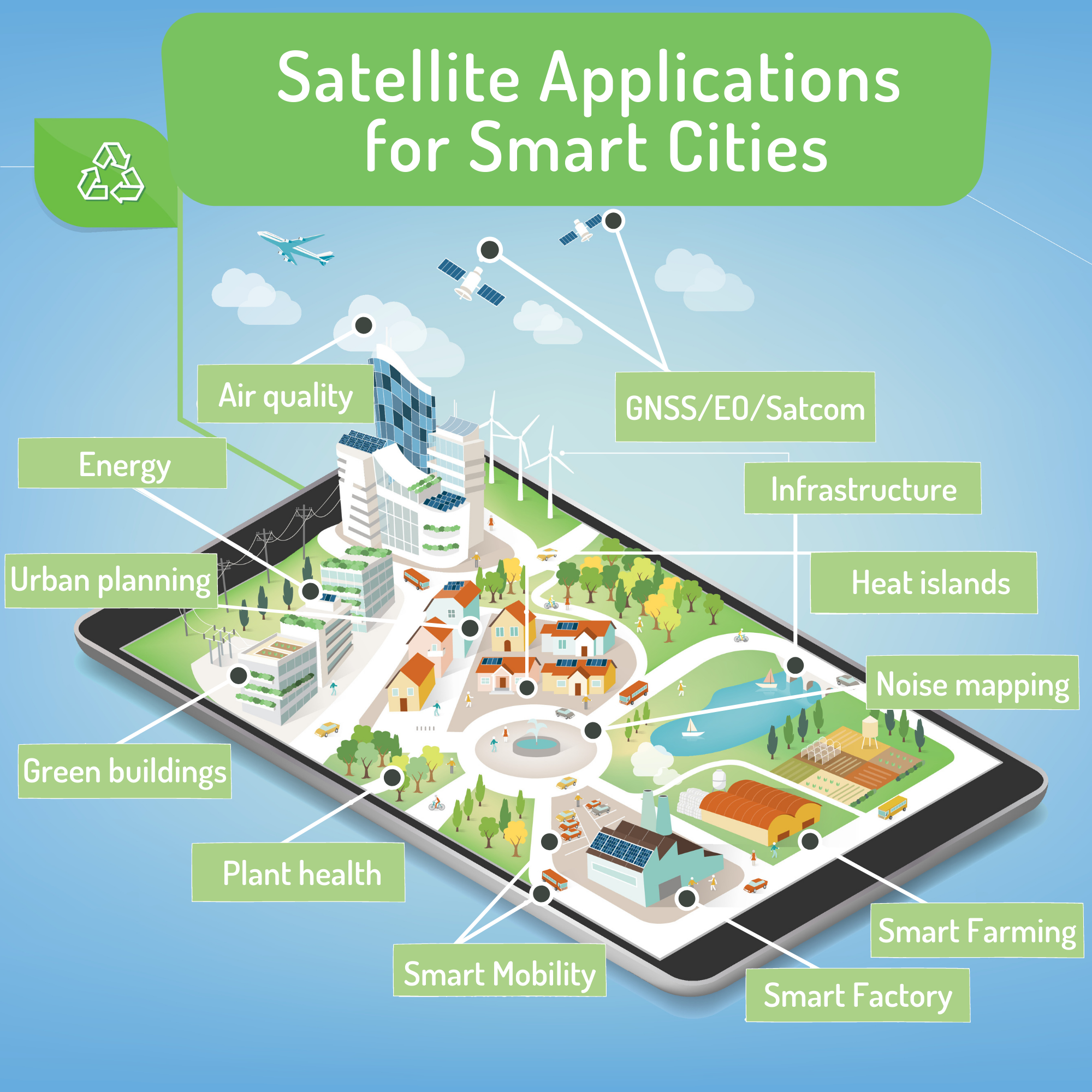
During the workshop, a variety of satellite-based services in cities were presented.
- For the production and management of solar energy, satellite imagery can help cities to exploit unused roofs or parking spaces to produce green energy. The two applications presented are In Sun We Trust and NextSENSE, two online services providing access to data on solar radiation at the city level.
- Earth observation data also carries precious information to foresee soil subsidence and to prioritise the maintenance of buildings, infrastructure and street pavements. The case of Amsterdam demonstrated how satellites help to better monitor bridges in the historical city centre, while the example of the Spanish Geological and Mining Institute showed how Earth observation helps to foresee soil subsidence due to groundwater extraction near the Segura river basin.
- Data such as from the Copernicus Atmosphere Monitoring Service (CAMS) can help cities to monitor pollutants in the air affecting urban health. The National Observatory of Athens presented an online platform (SMURBS EO Platform) that makes available data on fine particulate matter in cities based on satellite imagery. The CURE project (Copernicus for Urban Resilience in Europe) also illustrated how air quality data derived from Earth observation can be combined with other data to help local authorities define the best policies to make their cities more sustainable.
Furthermore, there are funding mechanisms to develop new services better adapted to user needs. Through the European Green Deal Calls, with specific calls for urban solutions, the European Commission makes available support and funding to increase the sustainability of our cities. In line with the development of the Copernicus services and the creation of the DIAS (Data and Information Access Services), many services based on Earth observation have also been funded.
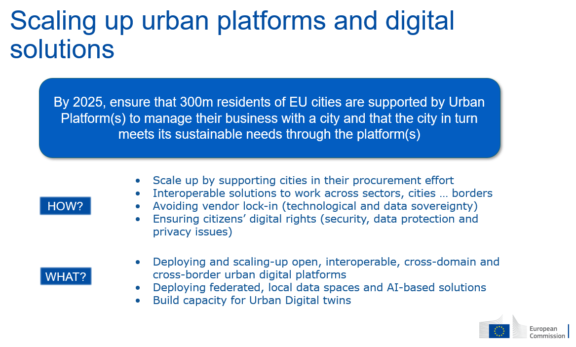
Slide from the presentation of Cristina Martinez, DG CONNECT
The lack of awareness among public administrations about the existence of services based on satellite applications, and in particular on Earth observation, is still a big obstacle. The information carried by Earth observation data remains difficult to find for the local city managers. This highlights the need to better communicate about the existence of satellite data and services. One way of doing this is to embed the data extracted from satellite imagery where the intended users actually look for information, such as on websites of regional and local entities dedicated to public services.
More case studies of satellite-based services demonstrating cost-effectiveness and their capacity to respond to cities’ concrete operational needs are required. Such case studies should not be showcased only to audiences with an interest towards ICTs and satellite applications, but should be presented to the general public and to local administrations in their language, avoiding technical jargon.
“Cities are hampered by budget constraints and low innovation culture – however the efficiency arguments supporting ICT investment are fully compelling and may be viewed as a solution to financial pressure. But for these arguments to win through, the services need to prove to be fit for purpose.” David Ludlow, Copernicus for Urban Resilience in Europe
The key to turn innovation into operation is to focus on needs. The Eurisy experience shows that the satellite-based services that are most likely to be used operationally and sustainably by local administrations, are those that have been conceived to respond to their specific needs and those that can be easily embedded into their operations, requiring little maintenance or technical skills.
To focus on needs means to involve city administrations actively in all phases of R&D projects, which requires a prior process of mutual education between city administrations and service providers. On the one hand, service providers need to learn about the priorities and needs of city departments, as well as about their structure, capabilities, and functioning. On the other hand, public administrations need to understand what parameters satellites can monitor, at what resolution and how often, and need to be aware of the time and resources they are expected to invest.
Finally, even when city administrations are aware of satellite-based services and convinced of their cost-efficiency, procuring them might not be obvious. Cities need support to procure satellite-based services because they often lack in-house experience to select the most pertinent service and to write the technical specifications for it.
 Energy management, connectivity, mobility, urban planning, protecting infrastructure against geo-hazards, air quality monitoring, the list of satellite applications goes on. However, there is still a lot to be done to turn innovation into operation. The speakers that contributed to our workshop are well aware that the transfer of satellite-based services to cities can only happen if these are clearly adapted to the operational needs and capabilities of local administrations. If all stakeholders focus their communications on such aspects, they can find the common language needed to co-design scalable satellite-based solutions enabling cities to make their green and digital transition.
The recordings of the sessions are available here. The presentations of the different speakers are accessible on the event page. You can also read the full report.