EO solutions for sustainable development: Hands-on e-shape services
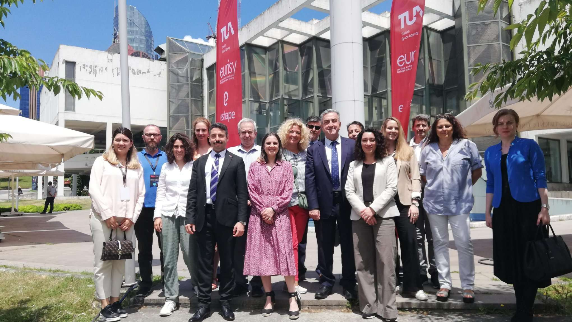
The first national e-shape workshop took place in Istanbul at ITU Suleyman Demirel Cultural Center. The workshop aimed to present some of the project’s pilots related to sustainable development and climate change by introducing the potential of satellite applications for the use and benefits of the users as well as EO market trends to the audience.
The workshop kickstarted with the President of the Turkish Space Agency, Serdar Hüseyin Yıldırım welcoming the participants and reaffirming the Agency’s willingness to increase cooperation with Eurisy and continue to actively participate in and contribute to the activities of the association: “Eurisy has such an effective multilateral nature poised to increase the exchange with international partners, sharing experiences, promoting national programmes to work cooperatively for sustainable development”. Dominique Tilmans, Eurisy President also emphasised the need for more of these workshops to support the switch from innovation to actual uptake of satellite-based services.
Annalisa Donati, Eurisy Secretary General, presented Eurisy’s mission and role as facilitator, matchmaker, and advisor in this process of adoption of satellite-based services. Explaining e-shape’s vision, fostering the development of EO solutions with and for the users, it has been highlighted how it complies with Eurisy’s practical work to advocate for more use of space data to tackle global social challenges on Earth such as climate change, among many others. All satellite applications including EO, have now a prominent role in supporting decision-makers in developing policies and strategies to mitigate the effects of climate challenge.
To increase resiliency in cities and natural ecosystems vulnerable to disasters and extreme weather events exacerbated by climate change, e-shape demonstrations consisted of four pilots focusing on air quality, urban climate projections in disaster-prone areas, resilient and sustainable ecosystems including agriculture and food as well as an early warning system for mosquito-borne diseases.
Camille Laine, Data Engineer from Murmuration, a French SME using satellite data to create environmental indicators, presented their project on super-resolution air quality monitoring service by obtaining both coverage and high resolution. Murmuration’s e-shape solution is focused on air quality measurements and predictions delivered through a user-friendly dashboard for decision-makers illustrating the evolution of air quality and moving it from the city level as provided today by satellite observations to the neighbourhood level.
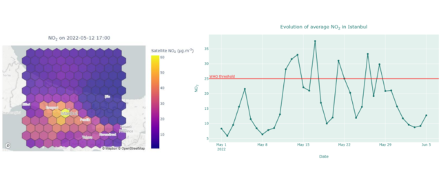
Murmuration presented its model based on correlation analysis by gathering in-situ CO data from ICOS stations, satellite CO data, meteorological data, population density and land cover from Sentinel 5P data and Copernicus Land and Atmospheric Monitoring Services, successfully applied also to other pollutant like CO2. During the workshop Camille illustrated a snapchat of the quality of the air in Istanbul as well as prediction for the following days, showcasing how those maps are immediately turned into actionable information for city officers.
GEOSS for disasters in Urban Environment pilot is a service based on sub-seasonal and seasonal forecasting chains for urban areas to help the cities authorities prepare for hazardous weather conditions. It has been presented by Martina Lagasio, the lead researcher for the e-shape from CIMA Research Foundation. Using satellite data products from Sentinel-1, the researchers produced FloodProofs forecasting systems including hydro-meteorological and hydraulics forecasting chain, flood forecasting chain, floodproofs forecast visualisation and flood area detection as outputs.
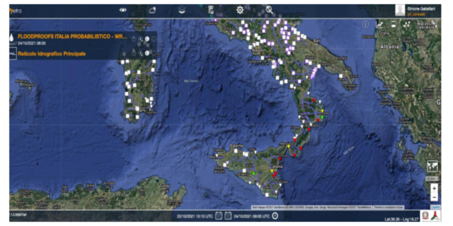
Selected indicators would be visualised in the MyDewetra platform, tested by Italian Civil Protection. Through a user-friendly visualisation outputs such as maps and time series projections can be consulted by civil protection agencies, hydro-meteorological predictions agencies, and disaster risk reduction institutions for the assessment of the impact of natural hazards over areas of interest. These services are meant to increase the preparedness and response of field operators to hazardous weather conditions as well as to build adaptation and mitigation strategies.
Within the set of 17 SDGs, the Sustainable Development Goal 2 is to “End hunger, achieve food security and improved nutrition and promote sustainable agriculture” supporting tackling climate change among many others. Underlying that climate change has a direct impact on food security Alexia Tsouni, a Research Associate from NOA, presented Resilient and Sustainable Ecosystems including Agriculture and Food. She introduced ResAGRI, a service platform developed for high-level monitoring, risk management and early warning. Raw satellite data from Sentinel 1, 2 and 3 and EO-derived parameters (e.g vegetation indices) as well as in-situ datasets such as atmospheric, soil and leaf measurements are used in the service platform.
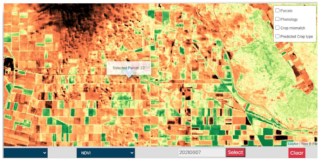
The service aims to provide high-resolution forecasts to give farmers and farmer consultants a crucial tool for the proactiveness of optimum seeding, fertilisation, irrigation, and harvesting times to increase productivity and profitability as well as the quality of the products offered to the market.
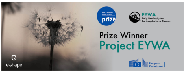
Early Warning System for Mosquito Borne Diseases (EYWA) was another pilot demonstration made by Mirka Rossi, the Communication and Dissemination Coordinator, by NOA. She pointed out that climate change is one of the major drivers altering ecological conditions for mosquitoes by mentioning Mosquito-Borne Diseases (MBDs) are present in over 100 countries.
To indicate the necessity to increase ecological resilience by controlling the MBD threat, she presented the need for a tool such EYWA early warning system. Obtaining EO data from Sentinel-2, Landsat 7, Landsat 8, MODIS, IMERG, and ERA5 as well as mosquito abundance and pathogen data collected in-situ, EYWA currently offers operational and pre-operational services for MBD outbreaks in five countries: France, Germany, Greece, Italy, Serbia. The solution aims for a global reach to expand the system service by applying the same methodology to non-European territories, showing the expansion of the project to Thailand as it provides risk models and mosquito abundance models at the municipality and settlement levels. Being operational since 2020, EYWA already got the 1st European Innovation Council Horizon Prize on Early Warning for Epidemics!
The workshop was the occasion to provide to the Turkish community with general insights on funding opportunities aimed at supporting companies and research institutes to further develop technologies and innovative services based on the European EO infrastructure and digital technologies, as well as the latest market trends to better understand the status and health of the industry demonstrate the value of using and investing in the EO sector for innovation on the technologies and best practices of emerging space countries successfully working for the establishment of innovative hubs. Local experts also joined the line up to showcase the cutting-edge indigenous projects in the field.
Jean Dusart, Project Officer of DG RTD European Commission, presented the EuroGEO initiative, aiming at bringing together Earth Observation resources in Europe, and funding Opportunities on Horizon Europe. The presentation focused on the opportunities offered by the EU mission adaptation to climate change with which around 150 regions and communities are supported to reach climate resilience by fostering the development and further integrating innovative solutions. Jean illustrated relevant funding opportunities as well as calls that might have an interest for Turkey together with EO in the Horizon Europe First Work Programme for next generation EO product and services development.
To provide a snapchat of the current markets trends related to commercial EO services, Francesca Piatto, EARSC project Officer, presented the results of the EARSC bi-annual survey on status and health of EO European ecosystem.
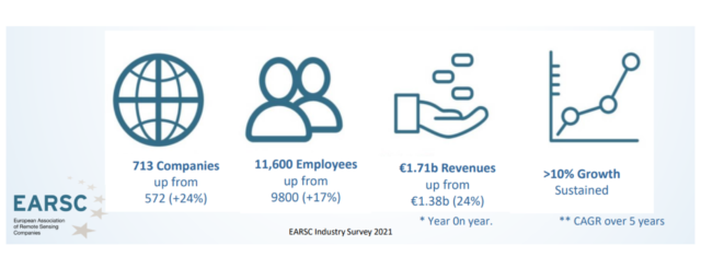
Interestingly, for both established companies and start-ups the most significant barrier to growth has been identified in the customer acceptance and the research for new customers and only after the lack for development funding. To articulate this reply the survey additionally investigated into the perceived challenges to customers uptake, the first one being the difficulty to convince customers about the business viability of the proposed EO solution closely followed, by the lack of awareness of the utility of EO applied to their business processes. To tackle the above mentioned challenges tailored workshops and infosessions should be implemented. Next, the difficulty of hiring qualified staff alongside the importance of the development of GEO skills was pointed out.
The Managing Director of the Bulgarian Academy of Science, Kamen Iliev, shared lessons learned and best practices for the establishment of innovation hubs. Web-based technology demonstration portals such as Copernicus Risk Relay were presented while emphasising the key role played by technological innovation in a sector at the edge like space. Hackathons and innovation competitions are mentioned as thrusters of space innovations motivating and engaging young minds in space entrepreneurial endeavors, while training them on the development of sustainable business plans. Kamen concluded advocating for the establishment of a Balkan Space Hub Project (BASH), a regional incubator to scale early business ideas accompanying them onto a journey towards technology maturation and commercial sustainability.
Grazia Fiore briefly presented the Copernicus and Me project, an initiative launched by Eurisy and CNES and displayed a video on a case study of a company, VIDA, supporting electrification in Sierra Leone.
Berk Üstündağ, Professor of Computer Engineering at ITU, gave a presentation on Remote Sensing and data fusion for Digital Twin Applications locally developed for the agriculture sector. Touching on the digital twinning concept, the potential of such an accurate virtual version of a physical object in real-time, for nowcasting and forecasting has been illustrated. Challenges mostly related to real-time acquisition and continuous monitoring (cloudiness, resolution difference, surface disturbance, etc.) as well as sampling and resolution differences are addressed by exerts to provide more and more actionable information to users in the agriculture sector.
Elif Sertel, Professor of Remote Sensing at ITU, presented Geospatial Artificial Intelligence (GEOAI) Methods for Remote Sensing Applications. After an overview of the increase in the use of EO data, land use and land cover classification on building detection problems relating it to pan sharpening and super-resolution, lack of real reference data and contradictory results among different spectral and spatial metrics.
The presentation stimulated lively discussions with local potential users communities.
Details on the speakers and presentations are available here or visit the project website e-shape.eu
More is yet to come! Stay tuned!