Space for Critical Infrastructure – Reflecting on the collapse of the Morandi Bridge
During the second webinar on the introductory part of “Space 4 Critical Infrastructure”, researchers and decision makers shared concrete measures and practices on operational satellite services to support relevant entities with the maintenance of viaducts, tunnels, and highways. Special emphasis was put on lessons learnt from the collapse of the Morandi Bridge and its impact on a European wide reflection on how to modernise critical infrastructure monitoring tools.
Views from the Liguria municipality following the reconstruction of the Morandi Bridge
Matteo Campora, Councilor for Transport, Mobility, and Environment of the Genoa Municipality, outlined the numerous socioeconomic effects of the collapse of the Morandi bridge in 2018. Stressing the need of adopting practices for an improved management of critical infrastructures, Genoa adopted in 2019 “Genova Lighthouse”, a sustainable and resilience strategy favouring the use of modern enabling technologies for the management of logistics and transport, the prevention of incidents, and the identification of mitigation actions.
The shockwave event represented by the collapse of the Morandi Bridge, mobilised a large number of cities within the Liguria region’s territory to provide mutual support and to share best practices in the use of smart technologies for risk analysis and prevention, to increase the resilience of infrastructure. Satellite data has not been exempt from this reflection and it is now used to identify landslides around the area of the Saint George Bridge, the viaduct which was inaugurated just two years after the collapse of the Morandi Bridge. Satellite data in combination with in-situ IoT sensors are also being exploited to evaluate the oscillation in the bridge, just to mention couple of examples.
From monitoring a single bridge to an entire network of roads and bridges
Elaborating on the complementary approach that involves different technologies, Giuseppe Forenza, Business Development Manager at Planetek Italia, presented Rheticus Safeway, a digital platform for the continuous maintenance of roads and bridges. The platform allows operators to move from a reactive approach to a proactive approach by understanding the trends of the movements that have an impact on the infrastructure. The system relies on a combination of ground motion analysis and radar satellite data to provide a complete overview of an entire asset. Through an intuitive interface, operators can immediately pinpoint locations where a significant mechanical stress has been reached. The millimetric precise ground motion maps result in actionable knowledge on how to plan and prioritise inspections.
The Anas use case provided a specific example on the activation of the Rheticus Safeway to monitor the stability of Italian roads and highways. Anas S.p.A. is the Italian society managing the complete cycle of design, maintenance and control of more than 32 000 km of roads and highways, 2100 tunnels, and 15 800 bridges. To complement its continuous surveillance activities, Anas relies on Rheticus Safeway, providing periodic reporting to highlight those infrastructures on which further inspection has to be addressed.
Multi-temporal satellite DInSAR techniques for the monitoring of the built-up environment
Simona Verde and Manuela Bonano, permanent researchers at the Italian National Research Centre, provided a comprehensive overview of how multi-temporal satellite data can help to monitor the built-up environment over large areas with sub-centimetric accuracy.
Synthetic Aperture Radar (SAR) provides high resolution and all-weather satellite imagery. The technique allows for the estimation of displacements caused by earthquakes as well as the monitoring of unstable areas affected by subsidence and landslides. With SAR imagery taken over different time series, the historical evolution of the deformation of objects (such as roads, railroads, dams, etc.) can be retrieved.
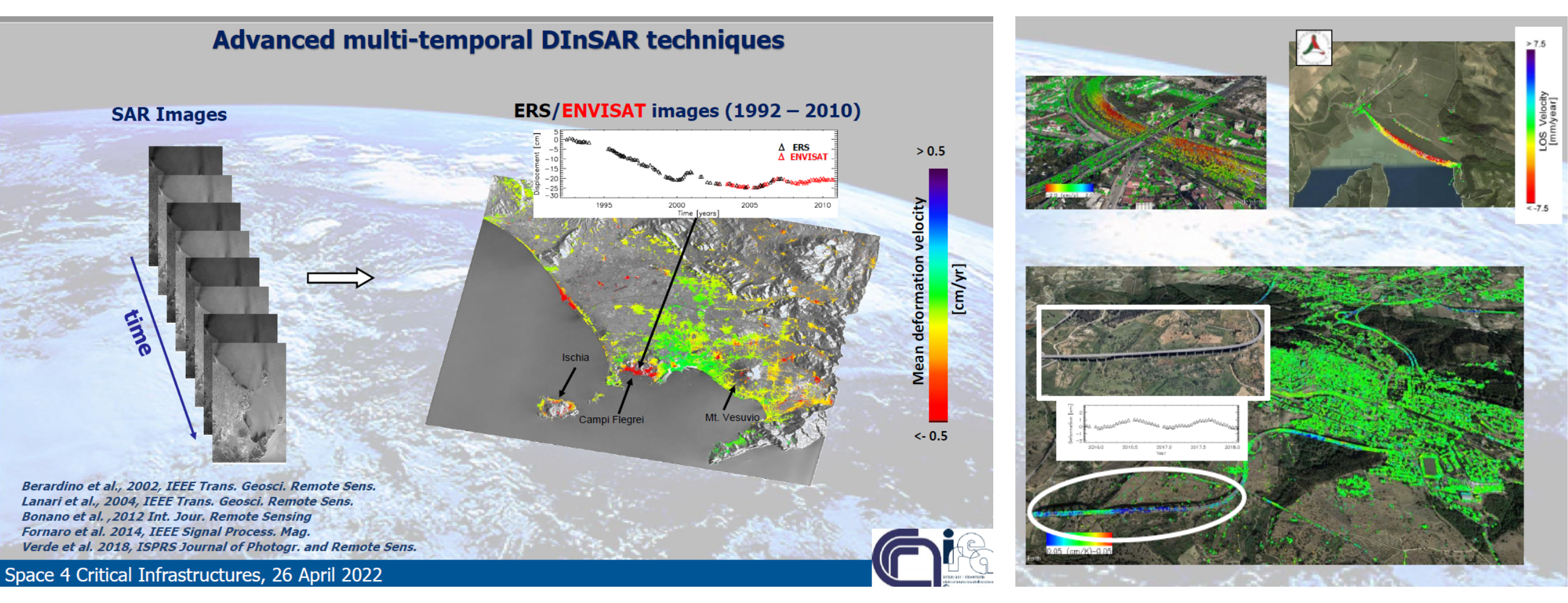
Following the collapse of the Morandi Bridge, the Italian Civil Protection Department together with the Italian Space Agency (ASI) requested Italian research groups highly qualified in SAR interferometry techniques to perform advanced analysis exploiting data relevant to the pre-event time interval in order to capture any possible early displacement associated with structural failures.
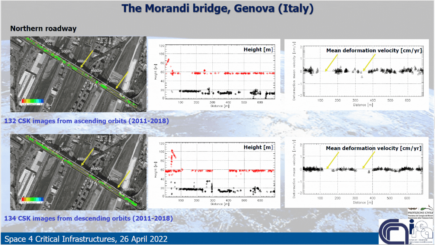
The results have been published here. The analysis did not reveal any significant displacement. The similarity between ascending and descending orbits shows that no deformation signals relevant to the pre-collapse event are detectable. The yellow arrows (on the Northern roadway) and red arrows (on the Southern roadway) indicate two areas with a lack of points due to secondary event effects such as vibration and wind.
Nonetheless the researchers outlined some lessons learnt, namely:
- Satellite data can be exploited to monitor trends overtime in combination with complementary observations (in-situ data) to support the prevention of infrastructure incidents.
- Rather than monitoring a single event, a large number of infrastructures can be monitored over time with satellite data.
- To facilitate the adoption of satellite solutions for the maintenance of critical infrastructure, the internal processes and specific challenges of the end user should be understood. This needs to be reflected in a user-friendly design of the solution.
- The potential of space data to boost the resilience of critical entities is being increasingly supported and recognised by regional and local authorities.
This webinar was part of the introductory online sessions presenting the state of play of the legislative process and the rationale behind the enlargement of the scope of the proposed EU Directive on the resilience of critical entities. The tragic collapse of the Morandi bridge has suddenly lifted to the very top of the political agenda of several European countries the issue of the integration of innovative technologies for the monitoring oof critical infrastructure.
A set of thematic webinars will be organised to illustrate operational solutions. The thematic sessions will cover the different sectors following the enlargement of the scope of the directive and will further demonstrate which kind of satellite-based services EU member states have at their disposal to boost the resilience of their critical entities.
The last introductory webinar “Putting the EC-proposal into action” before the thematic sessions, will take place on 24 May 2022, 10.00-11.00 CEST.
The full recoding of the second session is available here: