Asconit uses satellite-derived information to assist Champagne-Ardenne in assessing the environmental impact of a highway on riverbank vegetation
Asconit Consultants
Asconit Consultants is a French consulting company of medium size, employing 200 people on nine sites in France, Overseas Departments and Territories, and Vietnam. The company specialises in water management, sustainable land planning, energy and environmental protection using GIS and remote sensing. Asconit works in France, as well as abroad, mostly in Latin America, Asia and Africa.
The challenge
Asconit was contracted by the Directorate for Environment, Planning and Housing (DREAL) of Champagne-Ardenne to assess vegetation along riverbanks in an area where civil works for a highway were planned. This vegetation plays a significant role in environmental management because of its role in habitat and biodiversity conservation as well as in water quality.
European and national regulations require the DREAL to take compensation measures for any destruction of habitats caused by civil engineering works, by either not delivering building permits and/or by recreating habitats elsewhere.
It was therefore important for Asconit to correctly identify existing vegetation (or lack of it) so as to inform the DREAL on measures to be taken in order to compensate the destruction of vegetation along the riverbanks.
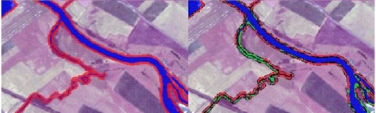
The solution
To detect vegetation along watercourses without inspecting the whole area on foot, Asconit used satellite images from RapidEye® combined with BDTopo® 3D maps then BDCarthage® hydrographical maps to locate it, with the best accuracy possible (in particular the presence of shrublands or trees along riverbanks). The images were obtained thanks to the GeoSud programme (GeoInformation for Sustainable Development) – a French database of annually updated and archive satellite data, free for public authorities.
The result
Thanks to the use of satellite-derived information, Asconit was able to prioritise portions of river banks that had the best potential as sites for compensation measures, such as replanting and/or densification of habitats.
The highway is currently under construction. On the basis of the prioritisation map delivered by Asconit, environment professionals are making the field trips to finalise the choice of habitat compensation sites.
”Satellite imagery helped us gain better insights on vegetation along riverbanks, quicker and cheaper than with previous methods” Maxime Vitter and Rémy Martin, Asconit