The Environment Agency in England, UK, uses satellite imagery to target recovery measures on flooded areas
The organisation
The Environment Agency (EA) is a non-departmental public body, funded in 1996 to pursue the protection and enhancement of the environment in England. The EA is funded by the Department for Environment, Food & Rural Affairs (DEFRA) and through business licences. Of the 10,000 people employed by the Agency, about 3,000 work specifically on forecast, mitigation and recovery activities related to flood and coastal risk management.
The challenge
A study performed by the Environment Agency in 2009 (Investing for the future, flood and coastal risk management in England, a long-term investment strategy), revealed that one in six properties in England is at risk of flooding from rivers, sea and surface water. Annually, floods inflict damages of an average cost of more than one billion pounds, which are borne by households, businesses, central and local government and other entities, including insurance companies.
The Environment Agency is responsible for monitoring the risks related to floods and to deliver timely and reliable information on flood extent to regional and local administrators in charge of recovery measures. The EA uses aircraft and ground measurements to assess floods. This procedure can be costly and time consuming for large flooded areas, especially during multiple events.
In 2009, the EA estimated that every pound invested in new and improved flood risk management assets reduces the long-term cost of flooding and coastal erosion damages by around £8. Indeed, the Agency has been actively exploring new techniques and solutions to assess flood damages more efficiently and for less.
The satellite solution
The EA can count on a team of 30 experts in remote survey and satellite imagery. In 2007, they thought of starting using EO for flood forecast, assessment and management.
The Agency acquires satellite imagery to monitor water levels and floods in collaboration with the Met Office. Moreover, the UK is a member of the International Charter on Space and Major Disasters, which provides data from various satellite assets for relief operations during major disasters.
In 2013 and 2014, England and Wales have been affected very severely by an exceptional run of storms, culminating in serious coastal damage and widespread, persistent flooding. During both years the Agency requested to the Civil Contingencies Secretariat of the Cabinet Office to activate the International Charter, while also benefitting from the satellite data made available by the EU Copernicus programme.
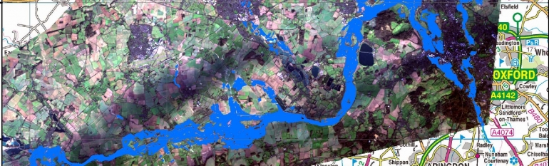
Between 24 and 48 hours from the activation, the satellite data provided for free by the Charter enabled the EA to produce and disseminate a cartography of the flooded area, indicating flood extension, damages and infrastructure in agricultural, recreational, commercial, industrial, residential, and urban areas.
Since the images provided by the Charter cover only the peak of the disaster, on both occasions the Agency also acquired satellite images (at a cost of approx. £10,000 for each time series), to continue mapping the flood water extent and its decrease and to then target recovering measures where they were most needed.
The result
Using satellite imagery allowed the Agency to have an overview of the flood extent and damages on a large area. The use of the imagery is now an operational practice of the EA when dealing with floods. Traditional methods like aerial photographs and ground measurements are still used, but combining them with satellite imagery enables the Agency to produce results much quicker and can help reduce costs. Particularly when large areas are affected, satellite imagery allows breadth and scale to be quickly assessed, targets for high resolution imaging to be identified, and change detection maps to be created for year-to-year, or event-to-event comparisons.
EA’s satellite-based maps are shared with the entities in charge of mitigation and recovery at the local level. The information can also be combined with other geo data, such as infrastructure and community information, to identify the areas which are most at risk and target mitigation and recovery measures. Indeed, in the last activation some of the post-event analysis was used in longer term modelling. The experience has proved to be so successful that it already inspired competent authorities in Scotland, Wales and Northern Ireland to consider it.
Satellite data provides an overview of flood extent and potential damages in a reliable, timely and cost-effective fashion.” Andrew Richman, Applications Manager, National Operations – Geomatics, Environment Agency