City of Vasto: relying on satellite navigation to enhance sustainable mobility
The Department of Transport, Sustainable Mobility and Smart City
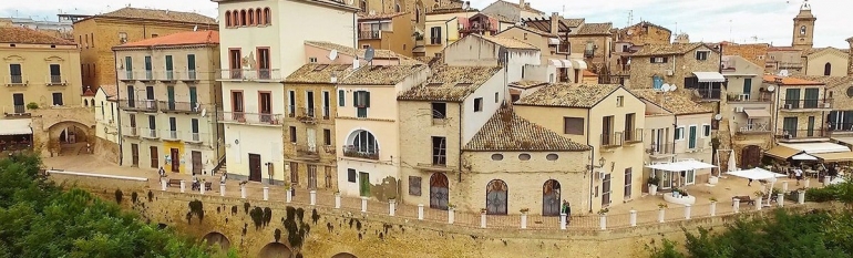
Vasto is a hilltop town on the Adriatic coast in southern Abruzzo, Italy. The City counts 41.000 inhabitants on an area of 70.65 km2. With a notable medieval centre, several buildings dating from the 15th century and a long coast including a natural reserve, the City is one of the main holiday destinations in Abruzzo, especially during the summer season.
The Department of Transport, Sustainable Mobility and Smart City of Vasto was created in 2014 with the task of designing and implementing the Sustainable Urban Mobility Plan (SUMP). The SUMP should facilitate intermodal transport in town, regulating and coordinating all urban mobility options, including trains, public buses, areas with traffic restrictions, parking spots, etc. Moreover, the Department is in charge of promoting green transport modes.
The challenge
The guidelines provided to local administrations by the European Commission foresee that Sustainable Urban Mobility Plans are developed in cooperation across different policy areas and levels of administration and with citizens and other stakeholders.
Hence, in order to build the Plan, the Municipality must screen needs and perceptions of inhabitants concerning urban mobility. The first step to collect such feedback is to provide stakeholders with all available information on mobility in the city.
The satellite solution
During the consultations organised by the City Hall to discuss the implementation of the SUMP, the Youth National Confederation of Artisans (CNA) proposed to build a web portal making available information on urban and regional mobility. Launched in November 2018, the VAMOS portal (Vasto Sustainable Mobility) will include all available information on public transport, free and paying parking, parking for persons with impaired mobility, green areas, restricted traffic areas, walking paths, cycling routes and electric bikes, among others. All these assets are geolocated through satellite navigation and users can click on the online maps to calculate their itineraries and be guided to their destinations.
Moreover, the portal includes information on iBike Abruzzo, the service of electric bike sharing recently created. The service is based on the MyCicero App, allowing users to register, manage payments and discover itineraries and charging stations in the territory. So far, five electric bike stations have been set up. Both the stations and the bikes are geolocated with satellite navigation, allowing users and service managers to know the position of the bikes in real time and to collect information on users’ itineraries. The iBike system has been implemented with the financial contribution of the Abruzzo region by a local SME working in the field of sustainable buildings and the consortium of commercial and tourist actors of Vasto Marina, the lower part of the city facing the Adriatic coast.
The results
The VAMOS platform allows inhabitants and visitors of Vasto to plan their itineraries within and around the city by combining different transport modes. The platform is currently being presented to the citizens through consultations and meetings. The feedback collected through such activities will be used by the Department of Sustainable Mobility to design the Sustainable Urban Mobility Plan.
In the future, the VAMOS platform will also include information on the car sharing service to be created and on the bus regional routes. Regional buses are already geolocated through satellite navigation. Indeed, the regional bus company Di Fonzo is part of the Polo Inoltra, a cluster of over 70 regional companies aimed at enhancing innovation in the sectors of mobility and logistics. When regional buses will be included in the VAMOS platform, users will be able to check their exact position in real time and to better plan their trip to Vasto. Today, the company includes the transport of a bike in the bus ticket. If current initiatives will be sustained, the VAMOS platform will allow the city to attract a greater number of cycling enthusiasts.
Moreover, the geolocated shared bikes are already providing the Department of Sustainable Mobility with precious information on cyclists and their itineraries. Such data could be used by the City to plan for the construction of new cycling routes according to users’ needs and even to adjust to traffic fluxes the price of advertisements on public routes.
Making available and geolocating all the information concerning mobility in the city is a crucial step in enhancing intermodal transport and green mobility. In particular, the information provided by the built-in GPS on electric bikes will allow us to better manage existing cycling routes and to plan for improvements in the future”.
Paola Cianci, Minister for the Environment, City of Vasto