Danube River Basin Directorate: satellite information for risk assessment
The organisation
The Danube River Basin Directorate – Pleven is a regional water management authority of the Bulgarian Ministry of Environment and Water. In line with the provisions of the EU Water Framework Directive, it is in charge of ensuring and providing public information on water quality and its efficient use, as well as of managing water and flood risk in the Bulgarian part of the basin.
The challenge
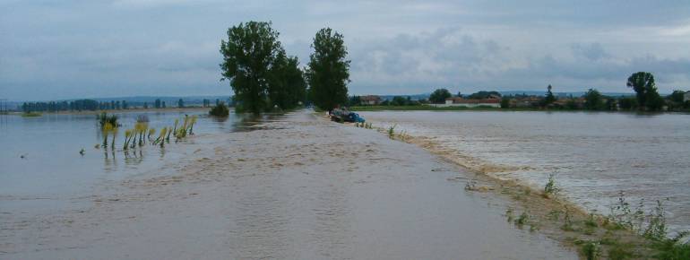
The floods in Bulgaria in 2005-2006 and the overflow of several reservoirs in the past years raised the issue at a national level about the need to prevent and better manage floods. To do so, improving the accuracy of the information made available to managing authorities was crucial.
According to the EU Flood Directive, a preliminary flood risk assessment (PFRA) was first needed to prepare the flood risk management plans for the Danube River Basin district. To realise the assessment, the Directorate selected an external contractor (RESAC) through a tender procedure.
The satellite solution
All standing water bodies, including reservoirs, were mapped using aerial and satellite imagery. Maps of past flood-events in Sofia-region and along the Danube, prepared also using satellite imagery and made available to the Directorate thanks to the SAFER project, allowed to foresee location and extent of potential future floods and thus to simplify the procedure to perform the preliminary assessment in certain areas, to evaluate the methodology used and to verify the results. The final maps are more precise and user-friendly than the cartography produced in the past. All the maps elaborated for the preliminary assessment have been made available on the website of the Basin Directorate, together with an interactive map geolocalising historical flooding, infrastructures, topographic characteristics and information on the potential damages and the level of flood risk.
The result
The information collected and analysed has provided the Danube River Basin Directorate with a solid basis to produce the flood-hazard maps and the flood-risk maps needed by the Danube River Basin Directorate to develop the district’s flood risk management plan. Thanks to the software used to elaborate the geolocalised information (SAFER), reference mapping can be generated and made available to public authorities within just six hours after a flood situation arises, while assessment maps of the damages caused can be delivered within 24 hours. Furthermore, the use of satellite imagery will allow an easier and more accurate update of the available information on land use.
“The satellite solution enabled us to merge the information and the lessons learnt about past floods with the current status of the infrastructure and to optimise the preliminary flood risk assessment.” Rumeliya Petrova, Danube River Basin Directorate.