FertiSat: Maps designed for optimal fertilisation of crops using nitrogen
The FertiSat online platform is a satellite monitoring tool for vegetative development of crops. It allows farmers to constantly analyse the conditions on their fields, and helps them to reduce the use of fertilisers.
The enterprise
Wasat Ltd. offers services based on processing of satellite data, as well as usage of GIS and IT systems, and participates in scientific and commercial projects related to satellite positioning and navigation. Most of the company’s customers are entities related to agriculture and environment protection but its services are also utilised by representatives of other sectors, for example by archaeologists.
The challenge
Optimal nitrogen fertilisation of crops remains a key issue in agriculture. Applying this mobile nutrient both at the right time and in the appropriate dose is essential for proper yields.
Crops’ demand for nitrogen depends on many different variables, such as the plants’ condition and phase of vegetative development, but also on meteorological conditions. Deficiency of nitrogen will result in, among others, poor growth, yellowing of leaves, reduction of tillering and finally lower yields. On the other hand, excessive nitrogen application results in greater risk of winter damage, lodging, diseases and late maturation.
At the same time, excessive fertilisation of fields with nitrogen causes unnecessary financial costs. Applying it while neglecting to supply other important ingredients – such as phosphorus and potassium – results in deterioration of soil parameters and properties. Moreover, nitrogen fertilisation is an area regulated by law, subject to the control of specialised institutions.
The satellite solution
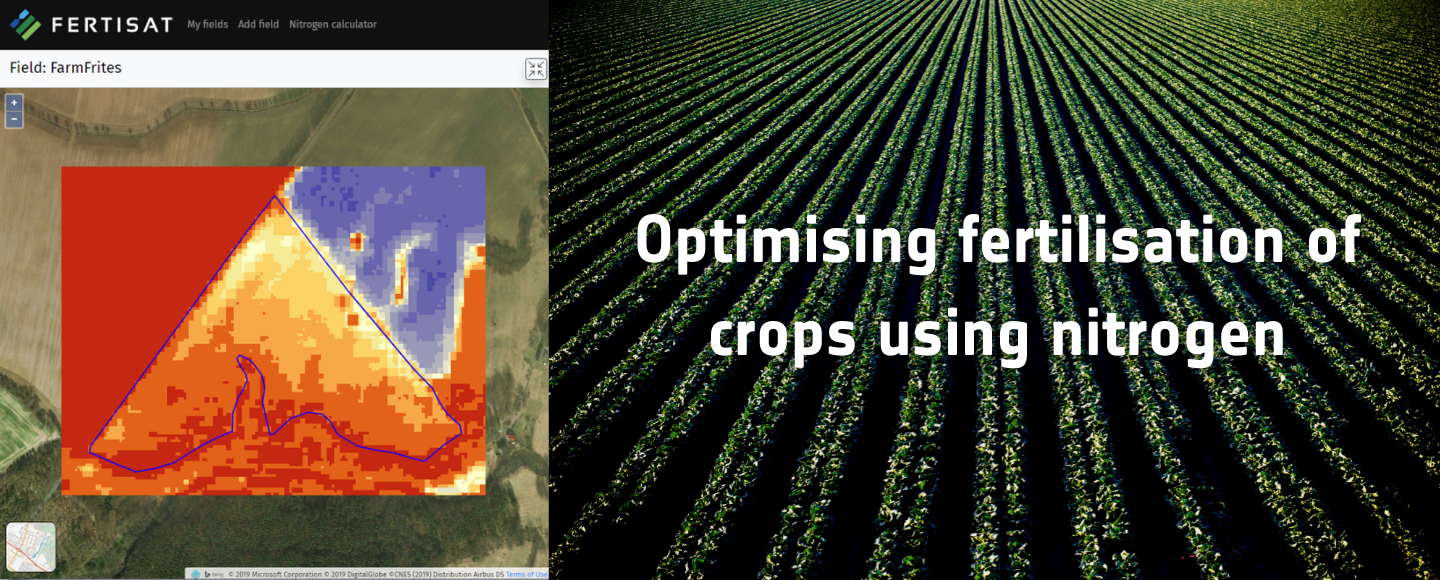
In order to respond to the need of optimising the use of nitrogen fertilisers, Wasat carried out the FertiSat project, supported by the European Space Agency. The project led to an online platform for agricultural producers. This tool enables the creation of application maps for variable nitrogen fertilisation dedicated to different crops, mainly cereals.
Multispectral imagery acquired by the European satellites Sentinel-2 is the source of input data for the system to work. Satellite images allow to define current plants’ condition and field differentiation using vegetation indexes right when the specific image was captured. While determining the desirable nitrogen dose for a given fragment of the field not only the crops’ actual condition and nutritional status are taken into account but plants’ growth stage, soil and weather conditions as well. Additionally, what distinguishes the service is the use of surface runoff model which enables to consider the soil moisture and nitrogen mobility on the fields.
FertiSat is mainly used for the crop management of cereals such as: wheat, rye, triticale and barley. It is important to emphasise that this online tool allows to adjust the proper dose of the fertiliser to particular phases of the vegetative development of a given crop species.
The results
The FertiSat platform supports users in the management of the agrotechnical treatment on their farms. In particular, utilising the service facilitates their decisions regarding the application of nitrogen and the implementation of fertilisation in accordance with the legal requirements. Thanks to the use of the online tool the whole process of fertilisation becomes much more effective and is perfectly adjusted to the topographic conditions and soil moisture as well as the current condition of crops.
The proper utilisation of the FertiSat service allows to reduce the use of fertilisers by approximately 10%, making it possible for farmers to significantly increase the profit per hectare. The beneficiaries of the solution include farms producing cereals, farmers’ associations and some other entities operating in the vast agricultural sector, for example producers and distributors of agrochemicals and of agricultural machinery.
The generated fertilisation maps are compatible with all types of controllers in sprayers and spreaders of fertilisers. The user also gets access to meteorological forecasts and a simplified nitrogen balance calculator. Satellite crop monitoring is possible throughout the whole growing season: farmers can constantly analyse the conditions on their fields on both computer and mobile device screens.
“Making use of satellite remote sensing in precision agriculture turned out to be a perfect path towards success for our company. It enabled us to gain satisfied customers, obtain growing revenues and have some positive environmental impact.” – Bartosz Buszke, CEO of Wasat.
The online platform is available here: Fertisat.com