Grand Palais: reviving history by playing with satellite navigation
The Grand Palais
The Grand Palais is a historic Parisian monument built at the occasion of the Universal Expo of 1900, and dedicated to “the glory of French art”. Three years were needed to complete the building and the adjacent Petit Palais, while a bridge over the Seine (Pont Alexandre III) and new avenue connecting the Champs-Élysées with the Esplanade des Invalides had to be built to make space to its 72 000 m2 ground floor. Some 40 contemporary artists worked at the statues, monumental groups and friezes embellishing the facades in a blend of styles characterising the Beaux-Arts architecture in vogue at the time.
Managed since 2010 by the Réunion des musées nationaux – Grand Palais (Rmn-GP), the building includes the distinctive 450 000 m3 air volume Nave covering the exposition hall, the Galeries Nationales and a science museum, the Palais de la Découverte. Designated as a historic monument since 2000, the Grand Palais receives two million visitors and hosts some 40 events every year. These include salons, exhibitions and happenings ranging from arts to fashion, photography, music, dance, cinema, theatre and sports.
The challenge
During the reorganisation of the buildings’ archives in 2012/2013, a large number of pictures and iconographic materials were rediscovered and classified, documenting the construction of the Grand Palais and the years following the rearrangement of the area. In accordance with the pedagogic scopes of the public building, the management of the Grand Palais started looking for innovative ways to disseminate such materials, while inclining a diverse audience towards arts and history.
The satellite solution
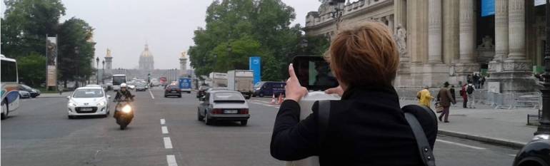
The solution was provided by Urban Gaming, a young start-up company who offered to create an interactive game allowing diverse publics to discover autonomously the area surrounding the Grand Palais, including the adjacent Petit Palais, the Gare des Invalides, the Pont Alexandre III and the Place de la Concorde. The game is based on a map on which different points of interests are geolocated and associated with quizzes, pictures and videos. Participants, divided in opposite teams of four or five, are given a tablet with a built-in GNSS sensor, and are asked to find the points of interest in order to complete the highest number of challenges in a given time. Trials are meant to drive visitors’ attention to architectural details that would normally pass unnoticed and which reveal the origins of the area. For example, while on the Pont Alexandre III, participants are asked to find a sign of the floods of 1910 on the quay or are shown an image of a woman on the bridge at the beginning of the XX century and are challenged to take a picture of the same scene as it looks today. The game is especially designed to meet the needs of a heterogeneous audience (questions for children are included) and to foster interaction among teammates of different ages and backgrounds. At the end of the game all teams gather together to share the pictures and videos realised during the competition.
The result
The game has been launched in its French version for the first time during the “European Heritage Days” on the 14-15 September 2013. It has been offered for free prior to registration to families, tourists, Parisians, young and young at heart interested not only in learning but in “living” history. 60 participants had the opportunity to participate. The enthusiastic comments of the participants convinced the management to offer the game again during the 2014 edition of the European Heritage Days.
“The interactive game plunges visitors into the past, unearthing the fun and curious of the great history”, Caroline Dubail-Letailleur, Cultural Project Manager, Réunion des musées nationaux – Grand Palais
![]()