Kenya: an insurance scheme based on satellite data for vulnerable pastoralists
The institute
The International Livestock Research Institute (ILRI) is a non-governmental organisation based in Nairobi, Kenya. ILRI works on livestock and poverty, by combining science and capacity-building to bear on poverty reduction and sustainable development. ILRI is running projects in Africa, South and Southeast Asia, and China. It employs over 700 staff from 40 countries.
The challenge
In Kenya’s arid and semi-arid lands, drought is the most pervasive hazard encountered by pastoral households. Pastoralists in these areas rely solely or largely on livestock, so livestock deaths due to drought have devastating impacts on their lives. Pastoralists are amongst the most vulnerable populations in East Africa.
Previous mitigation solutions for alleviating herders from the effects of drought and livestock deaths were not very efficient in the past; traditional insurers were not present in these areas, nor would they provide coverage due to the prohibitive costs of assessing claims on the ground. ILRI and Cornell University looked for a tool to evaluate losses without the need to physically observe the animals.
The satellite solution
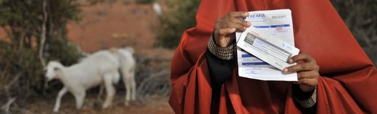
In 2010 ILRI, Cornell and other partners, launched an insurance scheme based on satellite imagery to predict and compensate insured pastoralists for livestock losses due to drought.
The solution relies on information on the state of forage (or vegetation cover) from the NASA Normalized Difference Vegetation Index (NDVI). If the vegetation cover is insufficient over time, animals will not have enough to eat and will perish. This prediction model allowed ILRI and Cornell to design an index-based insurance product using historical forage data that private insurers can sell to pastoralists and will provide them with financial compensation when a drought occurs and forage becomes unsustainably scarce.
In 2015 the Cornell-ILRI Team began to research how it could include crowd-sourced information on whether the vegetation seen via satellite was palatable for animals or not. About a hundred pastoralists were provided with smartphones to collect information on the status of vegetation on the ground, via a geo-localised application. They take pictures of the vegetation and answer basic questions such as the number of cows that can feed on it.
It is hoped that these new data, combined with satellite images, will eventually make forage maps more precise than ever before. If successful this would enable the development of still more precise and diverse risk management tools for these populations.
The results
IBLI provides a valuable safety net, protecting families from having to take drastic measures during times of drought. The insurance scheme has positive impacts on livestock productivity and herders’ income. In six years, payouts have occurred five times in different areas in response to drought periods. In Kenya, out of the 7,454 IBLI policies sold, 3011 policyholders have benefited from $118,170 in payout compensation. In Ethiopia, 2613 policies have been sold to date with 523 pastoralists benefiting from 2 payouts and $30,836 in compensation.
IBLI is currently provided in the market by three commercial insurance partners and is offered in five counties in Kenya and one zone in Ethiopia. The Government of Kenya is also set to launch the Kenya Livestock Insurance Program (KLIP) toward the end of 2015 that will offer limited IBLI contracts to targeted individuals in Northern Kenya with possible subsidies to the general public in later years.
Index-based livestock insurance based on remotely sensed vegetation data opens up new options for managing drought risk for previously-uninsured populations in rural Africa. Chris Barrett, Cornell University