Monitoring Eutrophication with Copernicus Marine Data
The Istituto Superiore per la Protezione e la Ricerca Ambientale and the National Institute of Oceanography and Applied Geophysics
The Istituto Superiore per la Protezione e la Ricerca Ambientale (ISPRA) and the National Institute of Oceanography and Applied Geophysics (OGS) play a key role in Italy’s marine environmental monitoring. As part of the implementation of the Marine Strategy Framework Directive (MSFD), they rely on Earth observation to improve the national evaluation of Good Environmental Status (GES).
The Challenge
The Marine Strategy Framework Directive (MSFD) was established to protect marine ecosystems and the biodiversity on which human health and marine-based economic and social activities depend. Among the 11 descriptors defined by the directive, Descriptor 5 (D5) focuses on eutrophication—the excessive enrichment of water with nutrients such as nitrogen and phosphorus, leading to algal blooms, oxygen depletion, and ecosystem imbalance. Monitoring eutrophication is essential to evaluate Good Environmental Status (GES) and ensure long-term ecosystem health, particularly in areas such as the Mediterranean Sea, where anthropogenic pressures are high and spatial coverage of in situ measurements is often limited.
The satellite solution
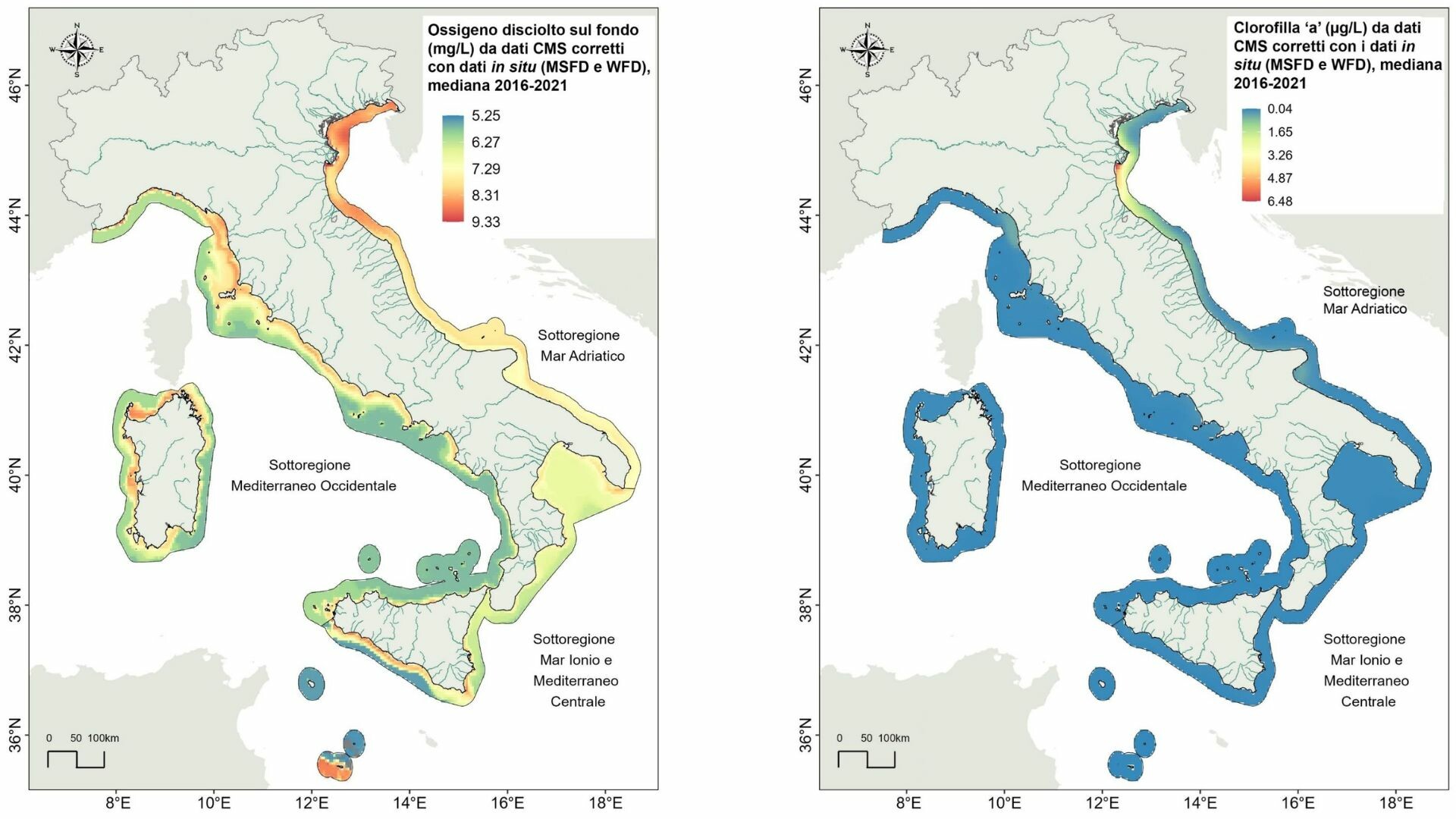
For the 2016–2021 MSFD implementation period, ISPRA and OGS used Copernicus Marine Service (CMEMS) physical and biogeochemical reanalysis data, applying bias correction with national in situ monitoring data to refine model accuracy in coastal zones. Key parameters such as chlorophyll-a, dissolved inorganic nitrogen, phosphate, and oxygen were analysed. Satellite data complemented in situ measurements and allowed broader coverage, including waters beyond 12 nautical miles. Future integration of ARGO float data will further enhance offshore monitoring.
The results
- National GES assessment for Descriptor 5 supported by CMEMS reanalysis data, with improved resolution in coastal areas through in situ integration.
- Extension of eutrophication monitoring to offshore waters thanks to planned use of ARGO float observations.
- Availability of consistent datasets beyond 12 nautical miles, covering Italy’s Exclusive Economic Zone.
- Improved scientific understanding of eutrophication dynamics, with evidence of declining trends in specific regions such as the Adriatic.
- Contribution to national compliance with the MSFD and Water Framework Directive (WFD), and support to ecosystem restoration and sustainable marine management.