RISE – Rapid Mapping to Transform Humanitarian Response
WASDI
WASDI is a joint venture of FadeOut Software and LIST based in Luxembourg that provides a cloud-based platform for accessing, processing, and analysing Earth observation data. Their mission is to democratise the use of satellite information by enabling users — from experts to non-specialists — to easily transform raw data into actionable insights. By integrating advanced cloud computing, artificial intelligence, and geospatial technologies, WASDI supports applications related to environmental monitoring, disaster management, land and water resource assessment, and sustainable development. Their platform offers a collaborative environment where users can process data, develop and share applications, and deliver services without needing complex infrastructure.
Luxembourg Red Cross
The Luxembourg Red Cross is a humanitarian organisation dedicated to protecting and supporting people affected by crises, both in Luxembourg and internationally. Through its Humanitarian Aid unit, it provides rapid emergency assistance in situations of conflict, natural disasters, and population displacement, delivering essential services such as shelter, water and sanitation, medical support, and protection. Beyond immediate relief, the organisation strengthens community resilience through long-term recovery and development programmes.
The challenge
The growing frequency and severity of disasters demands fast and informed responses. Yet, many crisis-affected areas remain hard to access and difficult to monitor. Limited observation in remote regions and the complexity of assessing natural hazards can delay critical decisions and intervention when time matters most. Humanitarian teams in the fields — often without satellite-data expertise — need simple, effective and friendly tools that turn data into clear, actionable information.
At the same time, recurrent emergencies, lack of budget and challenging logistics continue to strain operational capacity. These realities have pushed the International Department of the Luxembourg Red Cross to invest in innovation, research and strategic partnerships.
The satellite solution
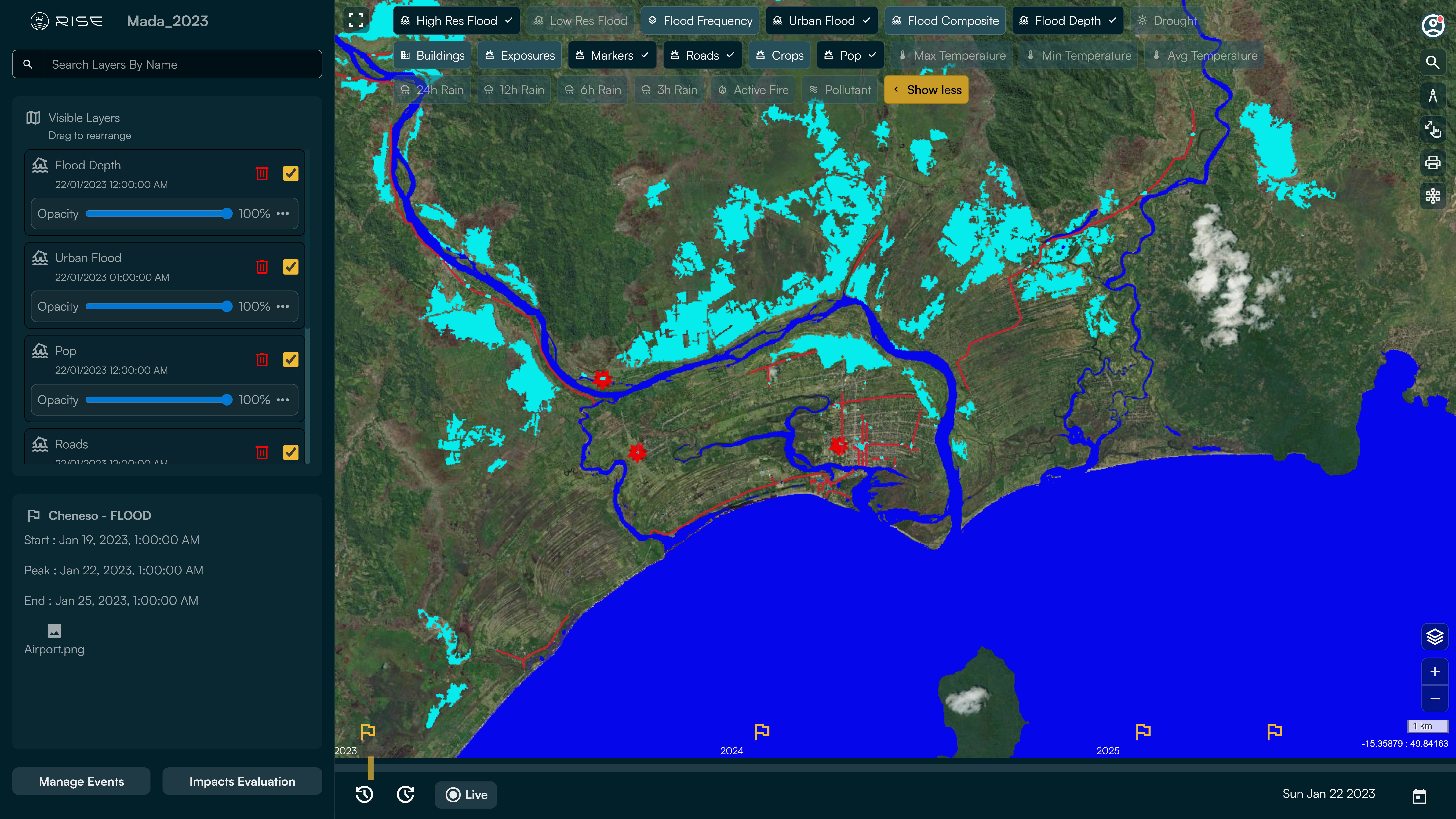
To address this challenge, the Luxembourg Red Cross, WASDI and LIST developed a platform through the WFP Humanitarian Innovation Accelerator (HIA) programme: RISE (Remote Imaging Support for Emergencies). This user-friendly tool was designed for non-experts and directly meets field needs focusing on flood and damage assessment, giving access to clear, usable information and supporting rapid decision-making.
By selecting an area on the map, users receive the latest available EO data, automatically processed into clear, ready-to-use hazard maps. It also leverages satellite image archives from multiple sources, enabling robust risk evaluation and comparison over time, as well as revisiting old hazards. Thanks to EO satellites, RISE displays near-real-time intelligence on floods, droughts and other risks, enabling faster and better informed decisions.
Fully automated and accessible worldwide, RISE is a complementary tool that allows humanitarian teams to assess events, understand impacts and support more people.
The results
Red Cross Madagascar have conducted a validation exercise that demonstrated that using RISE led to an 84.6% reduction in response time and an 89.97% decrease in operational costs compared to standard methods. For the Luxembourg Red Cross, the platform reduced reliance on in-person data collection, enabled faster coordination, saved budget, decrease the number of people put at risk in the exercise, and proved intuitive and adaptable to real-world field conditions. RISE serves as a complement to field expertise, helping responders carry out their work more effectively.
Key to this impact is clear communication between users and service providers and an intuitive interface that makes complex geospatial data immediately usable for operational decision-making.