Romania turns to satellites to crackdown on illegal deforestation
The Public Authority
Romania is home to two thirds of the last old growth forest in Europe. The Ministry of Environment, Water and Forests (MMAP) is the central public body tasked with protecting the country’s shrinking 6.4 million hectares of forest. Within the Ministry, the Department of Forests is responsible, among other tasks, for planning and implementing forest-related policies in compliance with Romanian and EU legislation.
The challenge
The Carpathian Arc contains the largest contiguous forested region in Central Europe covering 27% of the country’s surface. Romania’s forests are home to almost half of Europe’s wild population of brown bears, wolves and lynx. Yet, the equivalent of three football fields filled with trees is disappearing every hour.
Up to 50% of the exploited wood in Romania is the result of illegal logging. According to Green Peace Romania, a total of 45 509 cases of illegal logging were registered between 2013 and 2014. Beyond the environmental damage and loss of habitat for wildlife, illegal logging translates into financial losses for government agencies. Romania, which is among Europe’s main timber producers, is estimated to have lost €52.1 million in 2013-2014 due to illegal forest cuts.
The satellite solution
In 2014, to fight illegal cutting and curb losses, the government first instituted a mandatory digital tracking system for trucks transporting wood. The system, which assigns a number to each logging operation, tracks everything from how many trees are being cut, to their pickup and delivery locations. Even the truck drivers are registered in the system. However, the GPS data records proved insufficient to curtail legislation breaches. To bypass the system, truck drivers would use fake GPS loading points. According to the Environmental Investigation Agency, nearly half of the GPS loading points analysed in a month’s time appeared to be fake.
To add an additional control, the Ministry turned to TerraSigna, a GIS service provider, and a team of volunteering IT specialists. They created “Inspectorul Padurii” (The Forest Inspector).
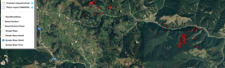
‘The Forest Inspector’ is a geographic information system that can ingest radar and high resolution satellite images from Sentinel 1 & 2, Landsat, OpenStreet and Google Maps. The software then scans successive images of the same areas to identify changes in the forest cover that indicate where logging has taken place. The data is refreshed every two to seven days (depending on the satellite crossing), which enables authorities to become aware of any illegal logging in almost real-time.
The satellite based map is further enriched with information coming from the government’s digital database and tracking system. Such information can include: who has permits to cut what and where, what the truck’s license plate number is, and when the logging took place. Protected areas are also monitored through the platform. In addition, the map can be used to identify fake GPS loading points, faster.
The result
Following the launch of the Forest Inspector in July 2016, the online platform and the mobile versions have been accessed by approximately one million users. Due to its multi-level access feature, both police and individuals can see who is doing the cuts, what type of wood is being cut, where and when. Thus, the platform brings together citizen activism, technology and authorities in the fight against illegal deforestation.
The successful implementation of the online portal has encouraged the team of volunteers involved in the project to look beyond Romania and extend its use to other countries and for other uses. The system could potentially present any other type of information, such as on waste management sites and wetlands, depending on user needs.
Thanks to a continuous stream of satellite data, public authorities are now better equipped to track illegal deforestation in almost real-time while empowering citizens to join in the fightBogdan Micu, Advisor, Ministry of Enviroment, Waters and Forests