SatBałtyk – Satellite Monitoring of the Marine Environment in the Baltic Sea
The SatBałtyk tool allows authorities to develop plans and decisions on how to protect the marine environment with satellite data.
The Institute of Oceanology- Polish Academy of Sciences
The Institute of Oceanology of the Polish Academy of Sciences was founded in 1983. Its mission is to seek, understand and communicate the scientific understanding of the marine environment and the issues related to its preservation and sustainable use of marine resources. The main geographic areas of interest of the Institute are the Baltic Sea and the seas of the European Artic.
In its work, the Institute aims at carrying out innovative, high-level scientific and technological research by providing expertise and new technologies targeting both the broader public and public and private stakeholders. In particular, the Institute carries out research in the fields of climate change, changes to the coastal ecosystems and marine biotechnology.
The challenge
Each of the nine different countries located on the coasts of the Baltic Sea has different economic and security priorities. Actions taken on one side of the coast may cause damages also on the other side of the coast, like the spread of industrial pollutants or wastewater from agricultural activities into the sea. Having knowledge of the marine environment and of the changes taking place is vital for reconciling the needs of the public and private stakeholders from different countries operating on the Baltic Sea in the fields of shipping, fishing, extractive industry, sewage, energy, maritime construction, recreation, among others. Furthermore, a comprehensive overview of the area is also fundamental to protect endangered species of marine plants and animals.
The satellite solution
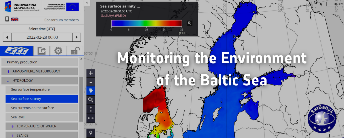
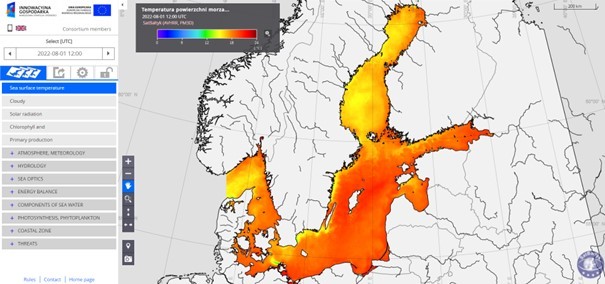
In 2015 the Institute of Oceanology launched the the SatBałtyk system, a satellite-based platform for monitoring the Baltic Sea environment in near real-time retrievable online. The platform features satellite data from multiple sources covering a time span of 20 years, as well as data collected through in situ instruments, oceanographic databases, and mathematical models. The platform offers the users – from public authorities responsible for maritime affairs, environment, and trade to private entities and researchers – a set of information based on eight parameters (atmosphere and meteorology; hydrology; ocean optics; solar radiations; seawater components; phytoplankton; coastal zones; hazards). Such data are then available on the online tool in the form of coloured maps where each colours illustrate the distribution of values for different factors within the entire Baltic area. Examples of characteristics for which the maps are generated are water salinity, water temperature or the direction and velocity of sea currents in the Baltic Sea.
Since 2015, the platform has been providing reliable information to ensure the protection of marine resources and its sustainable use. The platform features satellite data from multiple sources covering a time span of 20 years, including Landsat 8, Pleiades-1B, TerraSar-X, Sentinel-3A, CryoSat-2, and Metop-B, as well as data collected through in situ instruments, oceanographic databases, and mathematical models.
The results
The SatBałtyk platform tool aims at providing public and private entities as well as researchers with data on the multiple characteristics of the Baltic Sea, such as information on sea water temperature, salinity, the blooms of poisonous algae, or the appearance of pollution spots, including oil stains.
The platform is available and retrievable for free. The data available on the platform as well as the cartographic representations are downloadable. The tool has been created to facilitate the daily work of employees at national and local level responsible for the exploitation and protection of the Baltic area. In particular, the Polish Navy relies on the platform to collect information for the planning and execution of offshore activities. Widely retrieved by Polish authorities, such as the Ministry of State Assets or the Marine Office in Gdynia, in the period 2019-2021 over 120 thousand people used the tool and downloaded the digital maps.