Satellite imagery to monitor invasive species in the Karlovy Vary Region
The Karlovy Vary Regional Office
The Karlovy Vary Region is one of the 17 administrative units of the Czech Republic, in the western part of Bohemia. 43.1% of the regional territory is covered with forest, including the Protected Landscape Area of the Slavkov Forest. Among other tasks, the Regional office is leading a project aimed at reducing the incidence of invasive plants in the area.
The challenge
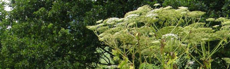
The Karlovy Vary Region is severely affected by invasive species, and in particular by the Heracleum mantegazzianum, commonly known as giant hogweed. This is a herb, 200-500cm tall, native of the western Caucasus. The species was introduced in the area in the second half of the 19th century and is currently infesting 2% of the region. Its spread was probably due to the complicated history of the region. Indeed, the displacement of German citizens after World War II and the establishment of a military area in 1950´s led to a lack of appropriate environmental management.
The giant hogweed spreads rapidly, outcompeting native species, and its elimination is very difficult. It represents a serious threat to biodiversity, ecosystems and landscape dynamics. Moreover, its juice is toxic and can produce skin diseases.
Early detection is crucial to manage invasive species more efficiently and at lower costs. Traditionally, aerial photography has been employed as the most common remote sensing tool to map and quantify invasive species. Nevertheless, as species normally disperse over long distances, this technique is insufficient to provide precise and timely information over large areas.
The satellite solution
Since 2000, a research consortium, including the Pruhonice Institute of Botany of the Czech Academy of Sciences, started a project aimed at exploring the potential of various surveying techniques to better manage invasive plants and to reduce the costs of extensive field campaigns.
The extension and location of the giant hogweed in the Protected Landscape Area of the Slavkovský Forest was mapped using a combination of aerial and satellite data. The data collected through aerial imagery offered a high accuracy to map hogweed on small extensions; satellite imagery allowed the team to identify large patches of the infesting species over the whole study area, and to monitor its impact on the regional landscape.
The results
By combining aerial and satellite imagery, it was possible to identify the progression of giant hogweed in detail and to verify the accuracy of the field mapping. Satellite-based data were used to choose the best study area to implement pilot projects, to prioritise interventions where the hogweed invasion is more likely to occur and to manage eradication and prevention activities. In the future, satellite imagery will be used to monitor the results of the activities currently implemented.
By combining aerial and satellite imagery it is possible to map the extension of invasive plants both at local and regional scales. We are looking forward to the Sentinel data to ensure continuity in our current efforts to monitor and eradicate such species”, Jana Mullerova, Pruhonice Institute of Botany CAS