SONS: the blind and visually impaired empowered through satnav
The association
Czech Blind United (SONS) is the national association of blind and partially sighted people in the Czech Republic. Its headquarters are located in Prague, while ~80 local branches are spread over the whole country. The member base counts almost 10, 000 heads and 100 employees manage its activities, from a specialised library and a dedicated shop to a navigation centre.
The current organisation was established in 1996 after the merger of two predecessors that had been carrying out activities for the past century.
The challenge
Taking the right tram, finding a zebra crossing, avoiding obstacles on the way are only some of the struggles that the blind and partially sighted face, when they are not being accompanied by a guide. SONS has made it a priority to eliminate barriers to their mobility and support their full access to public places. Some adaptations of the public infrastructure and its functionalities exist, such as acoustic traffic lights, or announcements of bus stops. But they are not always sufficient to enable the blind to navigate autonomously and with ease. SONS was looking for a system which could truly support its clients on the move.
The satellite solution
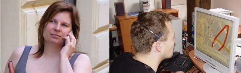
Ten years ago, the association set up a Navigation Centre in its headquarters to guide the blind and visually impaired during their trips.
Before starting his or her journey, the user calls the navigation centre via a dedicated number. Thanks to the satellite navigation receiver embedded in smartphones (or via an external satnav tracking unit), the SONS operator can locate where the person is calling from. The caller then tells the operator where he or she wishes to go. The operator finds the best itinerary by taking into account various data sources such as maps of the city, detailed 3D plans of subway stations, photos, plans, public transport schedules etc. Where available, Google Street View helps the operator to better judge the local situation and for example guide the impaired person to the proper road side, the one equipped by a sidewalk. The operator then guides the impaired person by phone until he or she reaches his or her final destination. Thanks to satellite navigation, the operator can follow the caller for the entire time, thus making sure he or she is going the right way.
In 2016, SONS added a new feature to its navigation centre. Thanks to a mobile app providing high-resolution video calls with current position, the operator can now see the street for the caller in real-time.
For longer journeys by train, SONS clients can also ask to be called before their stop. The operator can locate the person and call him/her e.g. five kilometres ahead of the destination.
The results
Thanks to the Navigation Centre, SONS clients are much more autonomous. They are satisfied with the quality of the service, and the association receives positive feedback. In the future, SONS is counting on the European satellite navigation system Galileo to provide an even more accurate location signal. Indeed, sometimes the height of the buildings misleads the satellite signal, which indicates an improper position to the operators. In addition, SONS is looking for better underlying data, such as precise and up-to-date coordinates of road constructions, to be able to guide its members even better.
Thanks to the Navigation Centre the visually impaired people are more autonomous on their journeys, and if they get lost, the Centre is able to help them. Zdeněk Bajtl, SONS.