South Iberian Coasts: Planning sustainable aquaculture activities using geospatial technology

The Andalusian Aquaculture Technology Centre relies on Earth Observation data to restore and develop profitable activities on humid areas and protect their biodiversity.
The Andalusian Aquaculture Technology Centre
The Andalusian Aquaculture Technology Centre (CTAQUA) is a non-for-profit private foundation based in Cádiz, Spain. Ever since it was founded in 2007, CTAQUA has developed multiple research projects and training in the field of aquaculture, addressing both the research community and the private sector. CTAQUA facilitates collaboration between aquaculture farmers, feed companies and other industry-related enterprises, academia and regional governmental institutions engaged in aquaculture activities.
The challenge
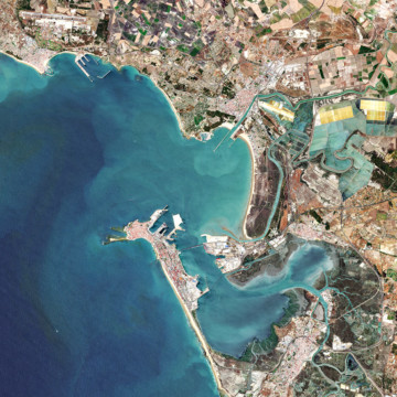
The south-western Iberian coastal area, shared between Portugal and Spain, has a common background and tradition in aquaculture. Being aquaculture a major growing economic activity in the region, overexploitation of coastal waters is a tangible risk. The consequence is that aquaculture directly endangers biodiversity. Planning aquaculture activities in advance is fundamental to improve the conservation status of coastal areas and their profitability, while promoting and implementing sustainable production methodologies and systems for a more efficient management of harvesting areas. Aquaculture planning involves multiple stakeholders, such as researchers, NGOs, regional and local fishery authorities, and other economic actors. Finding the right tool to set up ad hoc policies and favour the dialogue among all these actors represents a need and a challenge at the same time.
The satellite solution
Between 2017 and 2020, CTAQUA, the Andalusian Agricultural and Fisheries Management Agency (AGAPA), the Portuguese Environment Agency (APA) and the Portuguese Institute for Sea and Atmosphere (IPMA) are working together to identify the interactions between aquaculture and the environment in the South-Western Iberian coast, specifically in the Alentejo-Algarve-Andalusia area.
 Within the framework of the Interreg project AQUA&AMBI, that aims at strengthening cross-border mechanisms for the maintenance and recovery of biodiversity and ecosystem services, the three organisations developed a geographic information system (GIS) to monitor saline and aquaculture production areas. The GIS portal integrates multiple data, including Copernicus Sentinel-2 multispectral data on water temperature provided by the Spanish and Portuguese National Geographic Institutes, and in-situ data. The portal includes a cartographic map created by the project partners that functions as a zoning and regulatory instrument for entrepreneurs and administrations in the planning of economic activities within the aquaculture sector.
The results
Spatial planning based on satellite data provided an understanding of the south-western Iberian territory. It allowed for the identification of different administrative uses of the coastal zones for aquaculture activities, the assessment of suitable spaces for aquaculture development, and the compatibility with other sustainable economic activities in protected natural areas.
One of the users at local level of the GIS tool was the Andalusian authority for agriculture and fishery, responsible for the planning of aquaculture activities in the protected area in the Bay of Cadiz. The spatial planning through GIS allowed the identification of the different uses of the Bay to assess which zones should be dedicated to aquaculture and how to build synergies with other activities taking place in the bay, such as salt extractions, environmental protection initiatives and tourism.