The City of Barcelona uses a satellite-based service to monitor coastal water quality
The Department of Environment of the City of Barcelona
The City of Barcelona is located on the West coast of the Mediterranean Sea. The population is about 1.650.000 inhabitants. Around 7.5 million tourists visit the city every season.
The mission of the department of Environment of the City of Barcelona is to build a sustainable city, respectful of the environment and with no carbon emissions. To achieve these goals, the department implemented several initiatives, promoting the use of electric public transports and raising awareness on environmental issues in schools. An important transformation of the coast also took place in order to convert degraded areas into first quality beaches.
The challenge
The City manages eight beaches. During summer, around 200 people work to maintain the beaches in good shape. The high number of users (3.5 million in the summer time), as well as urban development pressure on the coast affect water quality and imply a significant effort from the municipality to offer a good service and to reliably control of water quality.
The Department of Environment thus needed an efficient and accurate tool to frequently monitor coastal water quality.
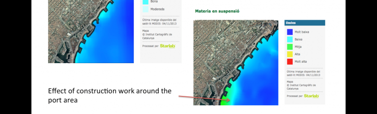
The satellite solution
The City of Barcelona adopted Barnamar, an information service based on satellite imagery, in 2010. It enables the Department of Environment to monitor four water quality parameters: the suspended matter, the transparency of the water, the temperature and algae bloom. The service is operational during bathing season, which runs from June to September. The maps are updated every two to three days, with a 24 hour delay for processing the images.
The service is used in addition to other monitoring tools such as visual control and analyses in laboratories.
The result
The service proves to be an efficient information and awareness raising tool. Indeed, the city benefits from real-time information on water quality disseminated through a dedicated webpage. A smartphone app for citizens, tourists and beach managers is in project. With four years of data available, the City of Barcelona is hoping to create historical maps to track the evolution of each parameter per beach and per season, establish the average level of each parameter and identify the areas most vulnerable to temperature increases or human activities.
“Thanks to satellite imagery, we can offer accurate information, in real-time, to citizens and tourists, and raise awareness on coastal water quality” Xavier Amat, Head of water supply and of the integral coastal management programme of the City of Barcelona