The Netherlands Human Environment and Transport Inspectorate: monitoring vessels’ emissions along the coasts

The Dutch Human Environment and Transport Inspectorate relies on Earth observation data to identify ships not adhering to international regulations on ships emissions.
The Human Environment and Transport Inspectorate
 The Human Environment and Transport Inspectorate (Inspectie Leefomgeving en Transport – ILT) is the supervising authority of the Dutch Ministry of Infrastructure and Water Management. Its mission is to enforce compliance with the law in multiple spheres of action, such as the use of high-risk materials and products, water, soil, and constructions, rail and road traffic, aviation, and shipping. Every year, ILT identifies possible risk areas where to intervene. Furthermore, the ILT Special Intelligence and Investigation Service can probe in case of criminal events that might endanger society, such as soil contamination or the use of hazardous substances.
The challenge
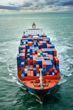
Every year, Dutch seaports handle over 550 million tons of goods, making the country a central shipping hub worldwide. Since 2020, the international regulations imposed by the International Maritime Organization (IMO) require seafaring vessels to meet lower emission standards. Indeed, shipping contributes heavily to air pollution, due to Nitrogen oxides (NOx) and Sulphur dioxide (SO2) emissions. Such emissions lead to a growing concentration of pollutants and particulate matter in the atmosphere. The ILT constantly monitors compliance with international rules for the Netherlands, especially observing emissions from ships. However, physically inspecting every ship coming to a Dutch port is practically impossible, and post-fact detection of noncompliant behavior outside of ports could be challenging.
The satellite solution
Since 2020, the ILT started to develop a monitoring system to track NOx emissions and identify incompliant ships. The first step was the implementation of a

study in cooperation with the Royal Netherlands Meteorological Institute (KNMI) and the universities of Leiden and Wageningen. Both entities developed an algorithm to measure ship pollution, that integrates EO data from TROPOMI (TROPOspheric Monitoring Instrument) with traditional monitoring means, as in-situ observations. The algorithm combined ship location information in the hours before and up to the time when the TROPOMI satellite pass over the area, with data on wind direction and speed in the high seas, and with satellite data on weather and air quality. Ship length and speed, together with EO data, helped the ILT in projecting the potential dispersion of pollutants by single ships.
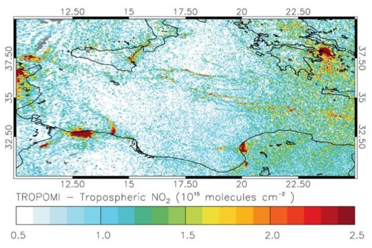
The Inspectorate monitored over 185 ships, evaluating their nitrogen dioxide emissions during ideal weather conditions. This data was then combined with ship location information in the hours before and up to the TROPOMI satellite overpass, and with wind direction and speed in the high seas. Ship length and speed together with EO data can help in projecting the potential dispersion of pollutants by single ships. In this way, the NO2 data identified are then compared with real ships emissions to verify if they are adhering to the international shipping regulations or not.
The results
The study showed that through EO data, it was possible to identify a heavier plume of NO2 from big and fast ships. The results of the study opened a new way of spotting ship emissions and identifying uncompliant ships.
The integration of satellite data in the ILT daily job reduced the load of work of the inspectors. The use of EO technology allows ILT in saving time and targets its resources on ad hoc inspections on those ships that are potentially uncompliant. In this way, ILT contributes not only to ensuring the adherence of the Netherlands to international legislation about shipping emissions, but also to the global emissions monitoring.