The Tensift Hydraulic Basin Agency uses satellite information to improve management of water resources
The Tensift Hydraulic Basin Agency
The Tensift Hydraulic Basin Agency federates the interests of water stakeholders in the Tensift-Ksob-Igouzoulen hydraulic basin. The area extends on 24,800 km² and is home to some 2.8 million inhabitants in six administrative districts. The Agency is mandated to plan, develop and manage the water resource in the region in an integrated, decentralised and concerted manner, in order to better exploit this resource in the interest of the local economy, while ensuring its sustainability.
The challenge
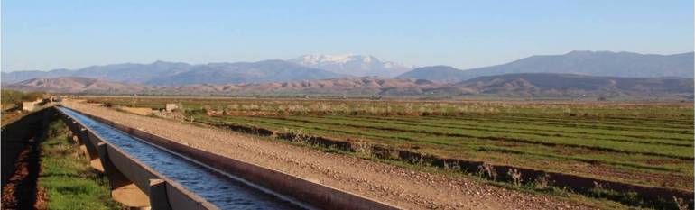
In the Haouz Plain near Marrakech, irrigated agriculture accounts for about 85% of the total water demand. Since 1990, a series of droughts and an increasing number of groundwater pumping sites for irrigation have caused a drop in the level of the Haouz aquifer (the main aquifer in the region), of up to two metres per year. To ensure a more efficient water use in the region, the Agency needed on the one hand to predict snow melting feeding into streams and reservoirs upstream. On the other hand, it needed to have a better overview on water demands from agriculture and its spatial distribution, in order to improve water use downstream.
“The Ministers responsible for Water (…) agree to (…) make best possible use of surface and ground water resources (…) by developing economies in all different uses”. Mediterranean Charter for Water, Rome 1992.
The satellite solution
Since 2010, the Tensift Hydraulic Basin Agency has used remote sensing to estimate the availability of and the demand for irrigation water, so as to adapt groundwater abstraction to such demand.
The agency receives daily satellite imagery with information on the snow cover and its water equivalent, which allows it to estimate water availability upstream. Downstream, land cover maps and data from satellite imagery, hydrometeorological ground stations and piezometric sensors, are combined to estimate evapotranspiration and assess water demand for agriculture.
The system is the result of a partnership among several local and foreign water management entities, research institutes and French and German cooperation agencies.
The result
The integrated model combining geographic information and satellite imagery, enables the Basin Agency to have a permanent, long-term and accurate overview of land use, of the evolution of irrigated areas and of irrigation water demand in the area and to plan measures to balance out availability and demand. This is especially important in the southern Mediterranean regions, where weather stations are scarce, especially in mountain areas.
“Satellite imagery allows to better estimate water availability and demand from agriculture, and to ensure an efficient and effective use of this resource in the long term.”
Brahim Berjamy, Head of the Information Systems, Tensift Hydraulic Basin Agency