VAKE: Improving Maritime Situational Awareness using satellite data and machine learning

VAKE developed a dashboard to detect and monitor vessels behaviour to supports governmental authorities preventing crimes and illicit actions.
Vake
Vake is a Norwegian company specialised in maritime safety and vessel traffic. The company was founded in 2019. It supports governmental agencies to monitor and survey national waters, offshore asset owners to detect dark vessels and reduce potential infrastructure threats and ship insurers to validate and verify the true chain of events.
The challenge
Back in 2008, the European Commission defined maritime domain awareness as the understanding of the activities associated with the maritime area that could impact the safety, security, economy and environment of the European Union and Member States. Acquiring a complete understanding of what happens at sea is relevant today due to the increased maritime traffic and activities in our oceans that are generating multiple threats to core sectors of the economy and to the breaching national security of coastal countries.
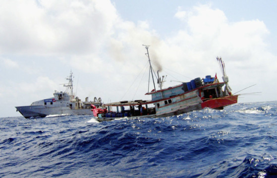
Illegal fishing, smuggling, and environmental crimes are the main challenges to be overcome. Detecting and identifying potential criminal vessels is key to filling information gaps and preventing illegal behaviours at sea. Technology already supports governmental authorities and businesses in spotting illicit activities, via drones, airborne sensors, and cameras, but satellite data can help in monitoring wide areas validating the in-situ measurements.
The satellite solution
To support governmental authorities and maritime economic actors, VAKE developed a dashboard that combines two core features: area monitoring and vessel tracking. The platform allows users to detect ships by using data from the Copernicus Sentinel-2 satellites and machine learning, cross-referenced with other vessel monitoring solutions, such as the Automatic Identification System (AIS) signal, that relies on GNSS technology.
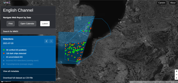
The dashboard allows users to select their area of interest and a temporal frame to obtain data on the ships there located, such as their size and direction. Users can access the images and information in the form of an interactive web report or download the data as a report file. In addition, the dashboard allows for the detection of dark and potentially illegal ships. Users can monitor their area of interest to verify if suspicious vessels are sailing with their AIS signal off, which can be an indicator for potentially illegal activities. By highlighting when this happens, it is possible to prevent these actions or retrace the route of criminals to determine if an action just happened or is it going to happen.
The results
VAKE’s dashboard is helping national authorities to improve sea monitoring, especially for the implementation of fishing analysis, and to prevent and prosecute environmental crimes. The algorithms that power the VAKE platform can also find additional applications to detect human trafficking, smuggling and seawater emissions.
Currently, VAKE is working with the Netherlands Coast Guard to complement and improve their maritime situational awareness. The collaboration with Vake allows the Coast Guard to extract insights on maritime activities from satellite data covering a wider portion of sea than the area they currently monitor. In the next future, VAKE and the Netherlands Coast Guard will combine automating alerts and collection of insights across multiple types of sensors, that will be key assets for maritime authorities.
VAKE is also working on expanding their geographical reach, including North and South America, and Australia. Furthermore, to provide users with night images, VAKE is currently developing products that include SAR (Synthetic Aperture Radar) satellite imagery.