The tech solution that can revolutionise search and rescue. Yet remains unknown to most
After attending the European Emergency Number Alliance’s 2018 EENA Conference & Exhibition in April, Eurisy took its “Sat4Alps” project and recommendations further to another key user segment – mountain rescuers.
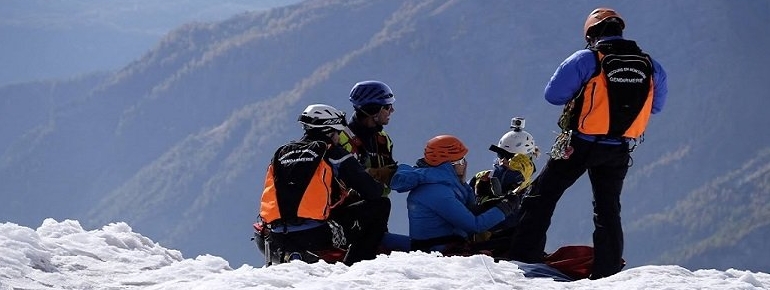
Chamonix, France was home to the 2018 International Commission for Alpine Rescue’s (ICAR) global conference this October, gathering 300 mountain rescuers from 37 countries. Rescuers, from as far as New Zeeland attended the event, as ICAR brings together 109 member organisations from all over the world to share the latest knowledge and technologies of mountain rescue. Celebrating 70 years of activity, the Commission connects expertise and knowledge into 4 technical groups: Air Rescue, Avalanche Rescue, Alpine Emergency Medicine and Terrestrial Rescue. Together they work to produce standards and policy recommendations to improve the security of rescuers and victims alike. In their own words, ICAR’s mission is to disseminate “learning from each other to improve mountain rescue and public safety”.
The four days event was rich in presentation and workshops on topics ranging from rope standards to avalanche rescue systems, recommendation on prevention of rock climbing accidents, cable clamps, air rescue study cases and more. An intense learning curve for us untrained urban dwellers, for whom the complexity of equipment and training behind rescue operations remains largely unperceived. To bring satellite-based services into play, Eurisy was joined by representatives from Iridium and Mobit Telecom for a hands-on outdoor workshop in the Italian Alps. The presented solutions included Iridium’s satellite communication connected devices and Mobit’s wrist-worn satellite personal location beacon (PLB) developed within Sinsin, a Horizon2020-GSA funded project.
Like many other communities, mountain rescuers share common challenges and needs. An avalanche poses similar threats and consequences, whether it happens in the mountains in the US, in Canada or the Alps. Time constraints in finding lost, missing or injured people in the wilderness or lightly populated areas, no matter the season or weather condition, are similar across borders and continents. Every minute counts in these critical environments. At times, minutes can turn into days for search and rescue teams and each mission requires considerable team planning, coordination and equipment. In many cases, the length of such missions is driven by one key information factor – the emergency caller’s location.
An accurate caller location in case of an emergency is one of the most significant pieces of information an emergency call-taker can use. And here is where satellites come in. With the exception of a handful of EU countries and New Zeeland, an emergency caller’s location is in most cases, determined and communicated to Public Safety Answering Points (or PSAPs) by local mobile operators based on their cell towers. The information is quick to obtain but this typically returns a large search area which can vary anywhere from 100 m to 40-50 km, depending on the tower’s location. Interestingly, when it comes to public perceptions on emergency calls, there is a considerable gap between expectations and reality. According to the GNSS 2017 Market Report, while citizens expect a location accuracy of 5-10 m, the current emergency location solutions available in EU Member States using mobile cell or sector ID are not even close to those numbers. And in emergency situations, this wide spectrum of accuracy can be a determining factor for a mission’s success.
In Europe, despite the existence of legislation to mandate accuracy and reliability targets for locating emergency calls, no member state has set any. In 2018, Europe’s civilian satellite navigation system, Galileo has become operational with 26 satellites currently in orbit, thus greatly adding to improving accuracy for emergency response-services. According to the EU funded Help112 project, improved emergency caller location could save 800 lives annually and up to €100 billion over the next decade. And the technology to turn these finding into facts is already here. Meet AML!
In a nutshell, Advanced Mobile Location (or AML) recognises when an emergency call is made from your smartphone and, if not already activated, activates the phone’s GNSS to collect the caller’s location information. Since July 2016 and respectively, spring 2018, both Android and Iphone operating systems are automatically AML enabled. Thanks to AML which relies on GNSS and handsets, location accuracy can be improved to as low as 50 metres. Moreover, where operational, 90% of location information arrives within 30 seconds of the network location being provided. Users don’t need to install any apps, nor make any updates to their phones. In addition, the European Emergency Number Association (EENA) estimates that implementation costs for PSAPs are negligible. Where implemented, the change has had a significant impact on search and rescue operations, as one ICAR attendant (one of the very few present aware of AML) explained to us.
Yet, despite this technology being readily available for deployment across the EU, only 11 countries have implemented it fully or partially. Current national legislations on handling emergency calls (which is a competency pertaining to local governments) are at the heart of this legislative hurdle. On their side, EENA has been working on raising awareness with local governments for quite some time now, but extensive ground still needs to be covered. Alongside rescue communities, the space sector can and should play a role in taking these user needs to decision makers and their constituencies. As such, in 2019 we’ll be aiming to further work across user rescue communities, partner organisations and the space sector to support AML take up. Stay tuned!