Workshop Connects Slovakian Service Providers and Stakeholders Protecting the Country from Growing Disaster Risks
On 30 November 2023, public authorities, researchers, civil institutions, private companies, and other relevant stakeholders gathered at the Slovak University of Technology in Bratislava to discuss local challenges related to natural hazards and how local entities could make the best use of the European space infrastructure to improve preparedness, strengthen prevention, optimise response, innovate recovery and overall boost resilience.
The workshop, Satellite-based Services for Disaster Risk Management”, was the Slovakian national edition of a series of workshops aimed at highlighting the potential of satellite applications during different phases of disaster risk management. Stakeholders dealing with the management of natural hazards shared their needs and experiences with the space community to streamline the process of integrating satellite-based services in disaster risk management. The workshop was organised by EUSPA, in collaboration with Eurisy and the Slovak Space Office, of the Ministry of Education, Science, Research and Sport of the Slovak Republic and Slovak Investment and Trade Development Agency (SARIO).
Slovakia, like all countries, faces growing risks of disasters from extreme weather events linked to climate change. In particular, Slovakia is naturally vulnerable to flooding from heavy rainfall events impacting the network of rivers running through the country. Extreme heat can amplify these events, and also create severe impacts in themselves. Flooding, combined with extreme heat, and the possibility of seismic activity in the region creates land displacement risks, such as landslides.
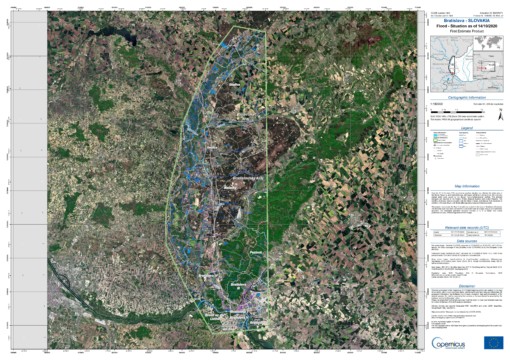
Map showing flooded areas (in light blue) in Bratislava during a flood event in 2020. Image taken from CEMS
Disaster response is made particularly difficult by Slovakia’s, hilly terrain, which is often densely forested. This makes access by first responders more difficult, and if terrestrial infrastructure is impacted by a disaster event, can make monitoring events, assessing damages, communicating with residents, and coordinating between emergency responders far more challenging, if not impossible. It is here where satellites can play an important role, as demonstrated by a range of service providers during the workshop.
“Space based data and services are providing solutions to the challenges we face nowadays. Satellite data enables efficient mapping and monitoring of the Earth’s resources, ecosystems, and events. These data ensure safety and security of our citizens, economies and society as well.” – Head of the Slovak Space Office Ms. Jana Rovňanová
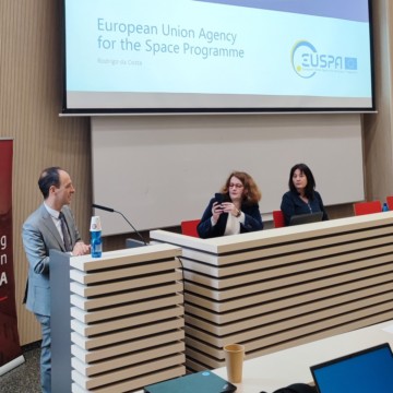
Rodrigo da Costa, Executive Director of EUSPA, presents the range of components and capabilities of the EU Space Programme.
Thanks to the EU Space Programme, Europeans now have access to satellite data from Earth Observation through the Copernicus programme and its space component of Sentinel missions, navigation through the Galileo, including its Search and Rescue component, as well as satellite communications, of which GOVSATCOM provides authorised public entities with secure satellite communications capabilities. These individual programmes provide the greatest impact in disaster risk management when used in combination with each other. According to Rodrigo da Costa, Executive Director of EUSPA, “Galileo, EGNOS, Copernicus, and GOVSATCOM are powerful tools individually, but an exponential achievement is reached when used in synergy. The Emergency Management and Disaster Response sector is one of the key sectors where this synergy is saving lives”.
EUSPA also offers a range of opportunities for entrepreneurs, including various funding initiatives, in order to foster innovation in using satellite data. A key cornerstone of EUSPA’s activities also includes the co-creation of solutions by establishing links with end-users, such as through ENTRUSTED network for GOVSATCOM presented by Flavio Sbardellati, Space Downstream Market Officer at EUSPA. By integrating end-users in the design process allows for a more efficient and effective definition of requirement and prioritisation of needs.
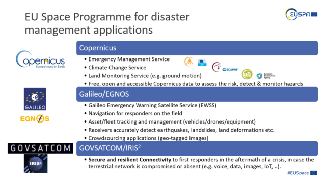
Applications of the EU Space Programme for Disaster Risk Management, taken from the presentation by Flavio Sbardellati
In transforming raw data from satellites into actionable insights and valuable advice for policy and decision makers, Slovakia hosts a healthy and growing ecosystem of companies developing solutions related to disaster risk management. Representatives from InSar.sk, YMS Slovakia, Kajo Services, Abmerit, the International Security and Emergency Management Institute (ISEMI), and MicroStep demonstrated their cutting-edge company’s services, offering a variety of perspectives on the capabilities of space data to support across all phases of the disaster risk management cycle.
Among the topics explored by services providers included using satellite-data for forest monitoring and management, which when done effectively can also support as a flood mitigation measure, radiological monitoring of agricultural areas around nuclear sites, improving public procurement for climate change adaptation and mitigation, and using satellites to enable sandstorm forecasting and thunderstorm “nowcasting”.
One of the key issues raised by many presenters was the need to integrate satellite data both with other forms of measurement, specifically in-situ data, but also with innovative processing and analysis methods, such as artificial intelligence and machine learning. Others meanwhile, highlighted the benefits of increased harmonisation and standardisation of risk assessment practices and processes.
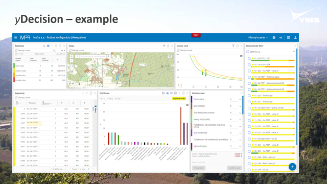
yDecision, as presented by Radovan Hilbert of YMS Slovakia, enables decision-support by combining and analysing multiple types of data, providing clear risk profiles and insights.
In response to the workshop, Michal Brichta, Director of Slovak Space Office – Industry Branch, stated “The dynamically growing Slovak space ecosystem already includes a broad variety of companies using satellite data to build innovative solutions for the disaster risk management domain. We are glad that this event provided them with a unique opportunity to present their solutions to potential buyers and engage in productive expert discussion.”
In parallel to the event, a survey has been distributed to Slovakian end-users to better understand their experiences, challenges, and needs in using satellite services for disaster risk management. The survey in particular seeks to understand what the main benefits are as well as challenges for different kinds of end-users in implementing satellite-based solutions. If you are a Slovakian end-user interested in the potential of satellite-based services, you can fill in the survey here.
The results of this survey as well as the detailed findings from the workshop will be presented in an upcoming report by Eurisy.