Eurisy Members’ Corner: Focus on the Netherlands Space Office
EO solutions for climate adaptation and mitigation, 31st March 2023
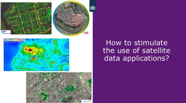
Not everyone is yet aware of the added value that satellite data can have to better prepare societies to the effects of climate change. The Netherlands Space Office supports companies willing to develop solutions that respond to the emerging needs of public bodies by exploiting data captured by satellites.
In this webinar, four companies benefitting from the NSO innovation programme presented products using satellite data to prevent and manage congestions on the electricity grid, to monitor the health of urban trees, to better prepare to floods, and to support agroforestry.
This first episode of the Eurisy Members’ Corner series of 2023 was designed by Ms Coco Antonissen, Advisor for Satellite Applications at the Netherlands Space Office (NSO).
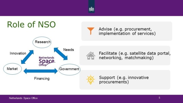
The Netherlands Space Office (NSO) stimulates the use of satellite-based data in civil society by advising the government (for example on how to procure or implement services based on satellite data), by facilitating access to data (e.g. through a data portal that can be accessed for free by Dutch entities), and by supporting the government and the industry to carry out innovation projects.
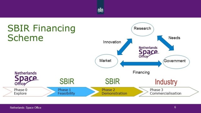
The Dutch ecosystem includes numerous private companies. The Small Business Innovation Research (SBIR) financing scheme is conceived to support the government to identify their information needs that could be filled with satellite data and to stimulate innovation in small businesses.
The SBIR scheme is structured in three phases, from dialogue with public bodies in order to identify their needs, to the feasibility assessment, the demonstration, and commercialisation of satellite-based services that respond to the needs identified.
The four companies sharing their experience within our webinar are currently in the third phase of this path, the commercialisation stage.
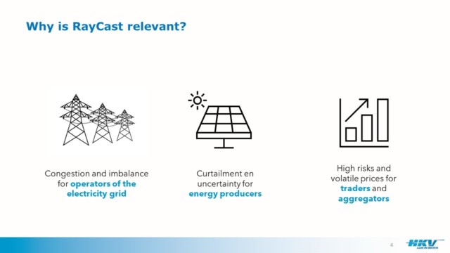
The first to present its services, represented by Ties van der Heijden, was HKV Lijn in Water. The company is demonstrating a solution aimed at anticipating congestions in the electricity grid, a challenge that could become a reality in a context of energy scarcity and global warming.
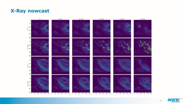
The “RayCast” system uses Earth observation data from satellites made available by the NSO to forecast cloud movements and improve their estimations of solar irradiance.
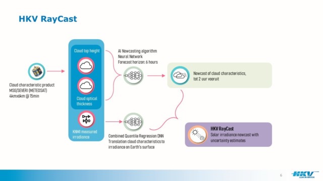
Currently, HKV is validating the forecasts realised with this system with actual grid data, and is contacting regional grid operators to make them aware of the solution. After completion of the validation phase, the first operational version of their product interface will be online by June 2023.
The product will allow operators to be better prepared to congestion imbalances on the electricity grids by knowing which parts of the grid will be overloaded in order to perform targeted interventions. Moreover, it would improve forecasts for solar energy producers, hence contributing to the energy transition in the Netherlands.
The effects of climate change will be particularly felt in cities, where extreme heat is increasingly common in summer, and heavy rains can cause severe damage to people and properties, as happened in central Europe in the summer of 2021.
Greeneries, and trees in particular, can be precious allies to make cities more resilient to heat and floods, in addition to contributing to increasing social well-being and health.
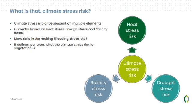
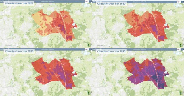
Cobra Groeninzicht, represented by Dirk Voets, is using the EO data made available within the SBIR scheme to better predict the effects of climate change on single trees in cities. Satellite data are used in this product to calculate the heat stress risk of the vegetation according to the vegetation type, and to estimate the water stress and the salinity of the soil.
The results are maps of the climate stress risk of the vegetation in a city that can help civil servants to identify the best areas to plant additional trees, and that at the same time allow for predictions of what will happen if no more trees are planted in an area.
For this system, the company uses high resolution data from satellites that allow them to assess the health status of single trees.
In the city of Helmond, where the system is being tested on publicly-owned trees, every single tree is mapped. The maps allow for the recognition of species for most of them, and for the identification of young trees.
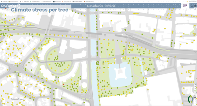
This is important information for cities to preserve their green capital and adapt to the new challenges posed by climate change. Civil servants can access forecasts on the status of each tree and decide on the interventions to be made, while citizens could exploit the data to take action in their own gardens.
The catastrophic effects of floods on human lives and assets have become alarming worldwide, making it urgent for national and local governments to improve their flood prediction systems.
Numerous Dutch municipalities and water boards are contributing to the perfectioning of the third solution showcased in this webinar, presented by Bob Ammerlaan from Weather Impact. This company exploits satellite-based data to improve extreme precipitation and flood risk forecasting.
Since 2019, they work with the Meteorological Institute of the Ministry of Infrastructure and Water to improve forecasts of extreme precipitations in the Netherlands.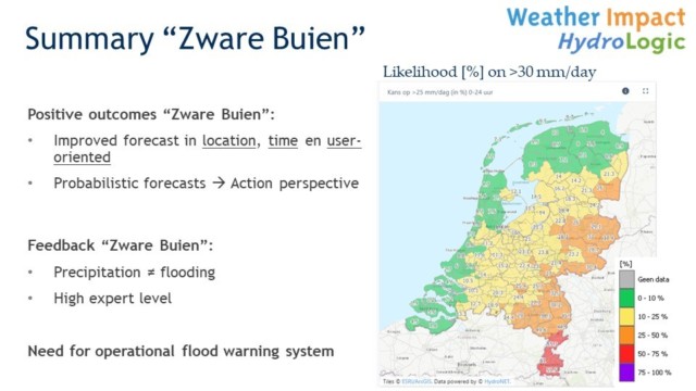
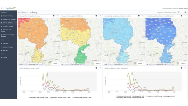
Weather Impact worked to increase the resolution of the information provided by the system already in place to reach a local scale and completed a first project in 2020. Nevertheless, the dashboard did not distinguish extreme precipitations from floods and contained too much information for emergency operators.
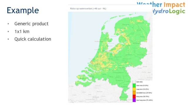
Within the SBIR funding scheme, satellite data, together with data from other numerous sources, was used to feed an algorithm that allows for fast flood forecasts and alerts.
Currently, to continue improving the product, ten Dutch governmental institutions, three municipalities, six water boards, and four regions are further testing it, with the intention of increasing its resolution, functionalities, and usability, and of including additional data sources by next year.
The last project to be showcased in the webinar, CarboCatch, developed by Space4Good in collaboration with the Louis Bolk Institute, was presented by Thijs Oosterhuis.
CarboCatch aims at facilitating the carbon credit market among farmers and industry, while supporting the government to plan future developments in agroforestry.
The Dutch Climate Agreement foresees to increase agroforestry in the country from the current 1.000 ha up to 30.000 ha by 2030. Agroforestry integrates pasture or crops with trees and shrubs on the same plot of land, which increases soil health, biodiversity and carbon sequestration.
While farmers are expected to reduce their carbon production, the industry is seeking to buy carbon credits from them. At the same time, public institutions need information to better plan agroforestry developments.
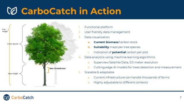
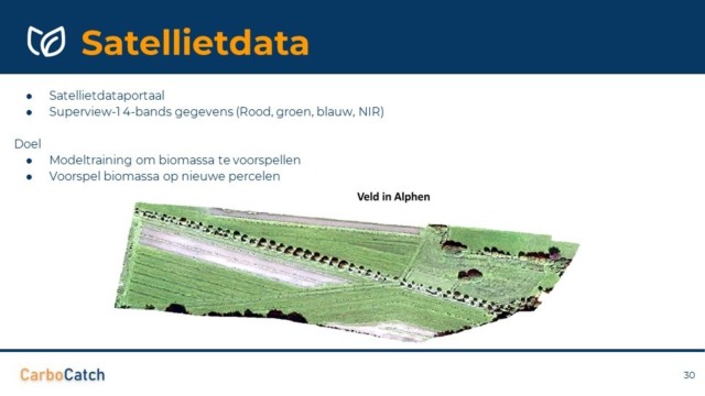
To provide data useful for all these actors while stimulating agroforestry practices, Carbocatch uses EO data and artificial intelligence (AI) to verify the biomass and carbon stocks and the potential carbon sequestration on specific plots.
The information is provided via maps on a dashboard including advice on which agroforestry practices are more suitable for specific plots.
We look forward to knowing how these products will further evolve and to talk about their operational uses and concrete benefits in the near future.
To know more about the activities of the NSO visit: https://www.spaceoffice.nl/en/
The presentations of the webinar are available here:
- How the NSO supports the development of EO-based solutions for climate adaption and mitigation, Coco Antonissen, Netherlands Space office
- Space-based solar irradiance nowcasting to manage traffic on the electricity grid, Ties van der Heijden, HKV Lijn in Water
- FutureTrees: Predicting the future of urban trees and their ecosystem benefits, Dirk Voets, Cobra Groeninzicht
- Extreme precipitation and flood risk forecasting, Bob Ammerlaan, Weather Impact
- Carbocatch – Bringing agroforestry home, Thijs Oosterhuis, Space4Good
The recordings can be accessed here: https://youtu.be/zHWceDhJNb4