Messages to the above: looking at art from the sky
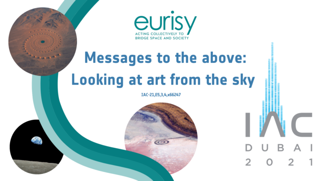
Eurisy aims at seizing the interest of the space community towards arts to launch a project specifically dedicated to “Space for Arts”. Today, the availability of new technologies and digital tools allows for unexpected synergies among artists and space experts. Indeed, the space sector is including arts among its areas of interest, as shown by the organisation of a session dedicated to Contemporary Arts Practice and Outer Space within the International Astronautical Congress. This interest is motivated by the multiplication of photographic, video and graphic experiences (also including VR and 3D), inspired or powered by space. Satellite imagery in particular, has been not only used to show the artistic beauty of the planet, but also to capture large artworks from the sky.
This paper provides a short introduction on how aerial photography and satellite imagery have changed our way of looking at the Earth, inspiring art movements and allowing for the discovery and appreciation of ancient and more recent artworks.
 Geological and landscape diversity is an essential part of the European culture. It characterises our rural and urban environments and offers the resources needed to sustain human communities. To monitor and protect geological heritage, back in 2003 the European Parliament stressed the importance of harmonising analytical methods to obtain comparable soil data and of increasing the exchange of information among Member States on soil, topography, structure and natural form of the land in Europe (European Parliament, 2003).
 Case study observations confirm that the merits of the technology alone, and a technology-driven approach does not necessarily convince the user to adopt this new technology. Similarly, top-down measures to stimulate take-up are not sufficient unless they are accompanied by grassroots support to the potential end-users in their appropriation of these tools. Such support should be based on a better understanding of their operational needs and the economic realities on the field. Cooperation between early adopters and potential end-users on a peer-to-peer level, relationships between potential end-users and technologists that are based on a real business case for service use as opposed to service development, as well as political drive on all levels, including sub-national, are all crucial factors in bringing about the kind of social change that translates an effective penetration of the satellite services within society. Paper presented at the
  This paper presented at the 2012 Toulouse Space Show, France aims at underlining, through concrete examples, how European cities make the most of satellite information and services, and satellite navigation in particular, to achieve sustainable urban mobility and create viable alternatives to owning a private vehicle. Without being exhaustive, the operational examples described also show how the integration of satellite information and services in urban mobility strategies benefits other policy areas of increasing importance, like health and social inclusion.
 The Paper outlined Eurisy’s User Programme objectives, methodology and results. It was presented at the IAF 2008 IAC conference in Glasgow (IAC-08-D1.1.01.)